Back مقاطعة يوتا (يوتا) Arabic Utah County, Utah BAR Юта (акруга) Byelorussian Юта (окръг) Bulgarian ইউটা কাউন্টি, ইউটা BPY Utah Gông (Utah) CDO Юта (гуо, Юта) CE Utah County CEB Utah County Czech Utah County, Utah Welsh
Utah County | |
|---|---|
 Historic Utah County Courthouse | |
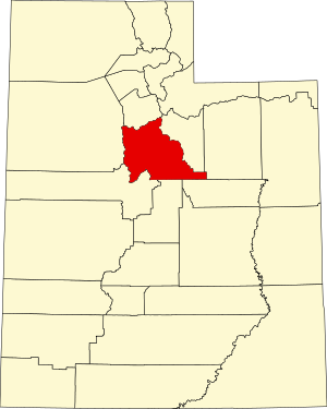
 Location within the U.S. state of Utah | |
 Utah's location within the U.S. | |
| Coordinates: 40°07′N 111°40′W / 40.12°N 111.67°W | |
| Country | |
| State | |
| Founded | January 31, 1850 (created) April 18, 1852 (organized) |
| Named for | Ute Tribe |
| Seat | Provo |
| Largest city | Provo |
| Area | |
• Total | 2,144 sq mi (5,550 km2) |
| • Land | 2,003 sq mi (5,190 km2) |
| • Water | 141 sq mi (370 km2) 6.6% |
| Population (2020) | |
• Total | 659,399 |
• Estimate (2023) | 719,174 |
| • Density | 310/sq mi (120/km2) |
| Time zone | UTC−7 (Mountain) |
| • Summer (DST) | UTC−6 (MDT) |
| Congressional districts | 3rd, 4th |
| Website | www |
Utah County is the second-most populous county in the U.S. state of Utah. The county seat and largest city is Provo,[1] which is the state's fourth-largest city, and the largest outside of Salt Lake County. As of the 2020 United States Census, the population was 665,665.[2]
Utah County is one of two counties forming the Provo–Orem metropolitan statistical area, and is part of the larger Salt Lake City–Provo–Orem, UT Combined Statistical Area. In 2020, the center of population of Utah was in Utah County, in the city of Saratoga Springs.[3]
Utah County is one of the fastest-growing counties in the United States, ranking among the top ten counties in numerical growth.[4] Correspondingly, Provo–Orem is among the top eight metropolitan areas by percentage growth in the country.[5]
Utah County is one of seven counties in the United States to have the same name as its state. The other six counties are Arkansas County, Hawaii County, Idaho County, Iowa County, Oklahoma County and New York County (commonly known as Manhattan).[6]
- ^ "Find a County". National Association of Counties. Retrieved June 7, 2011.
- ^ "State & County QuickFacts". United States Census Bureau. Retrieved December 30, 2013.
- ^ "Centers of Population by State: 2020". US Census Bureau. Retrieved June 3, 2024.
- ^ "Top 10 Counties in Numeric Growth: July 1, 2020 to July 1, 2021". US Census. Retrieved April 16, 2022.
- ^ "Top 10 Metro Areas in Percent Growth: July 1, 2020 to July 1, 2021". US Census. Retrieved April 16, 2022.
- ^ Joseph Nathan Kane; Charles Curry Aiken (2005). The American Counties: Origins of County Names, Dates of Creation, and Population Data, 1950-2000. Scarecrow Press. ISBN 978-0-8108-5036-1.
