Back أوتيكا (نيويورك) Arabic يوتيكا (نيو يورك) ARZ یوتیکا، نیویورک AZB Ютыка (Нью-Ёрк) Byelorussian Ютика (Ню Йорк) Bulgarian Utica (Nova York) Catalan Ютика (Нью-Йорк) CE Utica (kapital sa kondado) CEB Utica (New York) Czech Utica, Efrog Newydd Welsh
Utica
Unundadages (Mohawk) | |
|---|---|
City | |
Panorama of downtown from I-790 Liberty Bell Corner Looking south on Utica's Genesee Street Utica Tower and harbor lock | |
| Nickname(s): The Handshake City, Sin City, Elm Tree City[1] | |
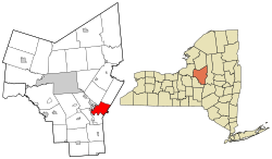
Location of Utica in Oneida County, New York and of Oneida County in New York state | |
 | |
| Coordinates: 43°06′03″N 75°13′57″W / 43.10083°N 75.23250°W | |
| Country | United States |
| State | New York |
| Region | Mohawk Valley |
| Metro | Utica–Rome |
| County | Oneida |
| Land grant (village) | January 2, 1734[2] |
| Incorporated (village) | April 3, 1798[3] |
| Incorporated (city) | February 13, 1832[4] |
| Government | |
| • Type | Strong mayor-council |
| • Mayor | Michael P. Galime (R) |
| Area | |
• City | 16.98 sq mi (43.97 km2) |
| • Land | 16.72 sq mi (43.31 km2) |
| • Water | 0.26 sq mi (0.66 km2) |
| Elevation | 456 ft (139 m) |
| Population (2020) | |
• City | 65,283 |
| • Density | 3,904.02/sq mi (1,507.33/km2) |
| • Urban | 117,328 (U.S.: 268th)[7] |
| • Metro | 297,592 (U.S.: 163rd)[6][a] |
| Demonym | Utican |
| GDP | |
| • Metro | $11.560 billion (2022) |
| Time zone | UTC−5 (Eastern (EST)) |
| • Summer (DST) | UTC−4 (EDT) |
| ZIP Codes | 13501-13505, 13599 |
| Area code | 315 |
| FIPS code | 36-76540 |
| GNIS feature ID | 0968324[9] |
| Website | cityofutica.com |
Utica (/ˈjuːtɪkə/ ⓘ) is a city in the Mohawk Valley and the county seat of Oneida County, New York, United States. The tenth-most-populous city in New York State, its population was 65,283 in the 2020 U.S. Census.[10] Located on the Mohawk River at the foot of the Adirondack Mountains, it is approximately 95 mi (153 km) west-northwest of Albany, 55 mi (89 km) east of Syracuse and 240 mi (386 km) northwest of New York City. Utica and the nearby city of Rome anchor the Utica–Rome Metropolitan Statistical Area comprising all of Oneida and Herkimer Counties.
Formerly a river settlement inhabited by the Mohawk Nation of the Iroquois Confederacy, Utica attracted European-American settlers from New England during and after the American Revolution. In the 19th century, immigrants strengthened its position as a layover city between Albany and Syracuse on the Erie and Chenango Canals and the New York Central Railroad. During the 19th and 20th centuries, the city's infrastructure contributed to its success as a manufacturing center and defined its role as a worldwide hub for the textile industry.
Like other Rust Belt cities, Utica underwent an economic downturn throughout the mid-20th century. The downturn consisted of industrial decline due to offshoring and the closure of textile mills, population loss caused by the relocation of jobs and businesses to suburbs and to Syracuse, and poverty associated with socioeconomic stress and a depressed tax base. With its low cost of living, the city has become a melting pot for refugees from war-torn countries around the world, encouraging growth for its colleges and universities, cultural institutions and economy.[11]
- ^ Bottini & Davis 2007, p. 90.
- ^ Bagg 1892, p. 20.
- ^ Cite error: The named reference
Cyclopedia 1879was invoked but never defined (see the help page). - ^ Bagg 1892, p. 199.
- ^ "ArcGIS REST Services Directory". United States Census Bureau. Archived from the original on January 19, 2022. Retrieved September 20, 2022.
- ^ "U.S. Census Bureau, 2011-2015 American Community Survey 5-Year Estimates". 2015 Population Estimates. United States Census Bureau, Population Division. Archived from the original on February 14, 2020. Retrieved April 20, 2017.
- ^ "Census Urban Area List". United States Census Bureau. Archived from the original on March 28, 2012. Retrieved May 7, 2015.
- ^ "Gross Domestic Product: All Industries in Merced County, CA". Federal Reserve Economic Data. Federal Reserve Bank of St. Louis.
- ^ "Feature Detail Report for: Utica". United States Geological Survey. January 23, 1980. Archived from the original on May 30, 2022. Retrieved April 15, 2015.
- ^ "U.S. Census Bureau QuickFacts: Utica city, New York". Census.gov. Archived from the original on May 30, 2022. Retrieved March 16, 2022.
- ^ Hartman, Susan (June 3, 2022). "How Refugees Transformed a Dying Rust Belt Town". The New York Times. ISSN 0362-4331. Archived from the original on June 5, 2022. Retrieved June 5, 2022.
Cite error: There are <ref group=lower-alpha> tags or {{efn}} templates on this page, but the references will not show without a {{reflist|group=lower-alpha}} template or {{notelist}} template (see the help page).


