Back أكشاي Arabic اكشاى ARZ वैशाली जिला AWA वैशाली जिला Bihari বৈশালী জেলা Bengali/Bangla Vaishāli CEB Vaishali (distrikt) Danish Vaishali (Distrikt) German Distrito de Vaishali Spanish Vaishali barrutia Basque
Vaishali district | |
|---|---|
 | |
 | |
| Country | |
| State | |
| Division | Tirhut |
| Established | 10 December 1972 |
| Headquarters | Hajipur[1] |
| Government | |
| • Educationist | Shri Rajdeo Ray |
| • Lok Sabha constituencies | Hajipur, Vaishali |
| • Vidhan Sabha constituencies | Hajipur, Lalganj, Vaishali, Mahua, Raja Pakar, Raghopur, Mahnar, Patepur |
| Area | |
• Total | 2,036 km2 (786 sq mi) |
| Elevation | 51 m (167 ft) |
| Population (2011) | |
• Total | 3,495,021 |
| • Density | 1,700/km2 (4,400/sq mi) |
| Demographics | |
| • Literacy | 66.60% |
| • Sex ratio | 1.895 ♂/♀ |
| Language | |
| • Official | Hindi |
| • Additional official | Urdu |
| • Regional Languages | Bajjika |
| Time zone | UTC+05:30 (IST) |
| PIN | 8441xx (Vaishali)[2] |
| Major highways | NH 22, NH 31, NH 322 |
| HDI (2016) | |
| Website | Official website |
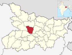
Vaishali district is a district in the Indian state of Bihar. It is a part of Tirhut division.[4] Vaishali is known for being the birthplace of Mahavira of the Jain religion. Hajipur, its largest city and district headquarters, is known for its banana forest. The district is connected via the NH-77 and NH-322 highways, Gandhi Setu and Jay Prakash Setu (JP Setu) Bridges over(Holy) Ganga River which connect the state capital Patna, the division headquarters Muzaffarpur, and the eastward district Samastipur.
- ^ "District headquarter of Vaishali". Archived from the original on 17 May 2021. Retrieved 3 June 2021. vaishali.nic.in
- ^ Vaishali
- ^ "Development of Human Development Index at District Level for EAG States" (PDF). March 2016. Archived (PDF) from the original on 2 June 2021. Retrieved 31 May 2021.
- ^ "Tirhut Division Muzaffarpur | An Official website of Tirhut Division Muzaffarpur | India". Retrieved 16 September 2024.