Back نهر فيلاين Arabic Vilaine BAR Вілен Byelorussian Вилен Bulgarian Gwilen Breton Vilaine Catalan Vilaine CEB Vilaine Czech Afon Gwilun Welsh Vilaine German
| Vilaine | |
|---|---|
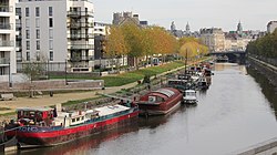
 The Vilaine in Rennes. | |
| Native name | La Vilaine (French) |
| Location | |
| Country | France |
| Physical characteristics | |
| Source | |
| • location | Juvigné, Mayenne |
| • coordinates | 48°13′46″N 01°03′11″W / 48.22944°N 1.05306°W |
| • elevation | 175 m (574 ft) |
| Mouth | |
• location | Atlantic Ocean |
• coordinates | 47°30′20″N 2°29′57″W / 47.50556°N 2.49917°W |
| Length | 218.1 km (135.5 mi) |
| Basin size | 10,882 km2 (4,202 sq mi) |
| Discharge | |
| • average | 80 m3/s (2,800 cu ft/s) |

The Vilaine (French pronunciation: [vilɛn] ⓘ; Breton: Gwilen) is a river in Brittany, in the west of France. The river's source is in the Mayenne département (53), and it flows out into the Atlantic Ocean at Pénestin in the Morbihan département (56). It is 218 km long.[1]

