Back Voeren Afrikaans فورين Arabic Вурен Bulgarian Voeren Breton Voeren Catalan Voeren CEB Voeren German Voeren Esperanto Voeren Spanish Voeren Basque
Voeren
Fourons (French) | |
|---|---|
 Sint-Martens-Voeren | |
| Coordinates: 50°45′N 05°47′E / 50.750°N 5.783°E | |
| Country | |
| Community | Flemish Community |
| Region | Flemish Region |
| Province | Limburg |
| Arrondissement | Tongeren |
| Government | |
| • Mayor | Joris Gaens (Voerbelangen, N-VA) |
| • Governing party/ies | Voerbelangen |
| Area | |
• Total | 50.61 km2 (19.54 sq mi) |
| Population (2018-01-01)[1] | |
• Total | 4,160 |
| • Density | 82/km2 (210/sq mi) |
| Postal codes | 3790, 3791, 3792, 3793, 3798 |
| NIS code | 73109 |
| Area codes | 04 |
| Website | www.voeren.be |

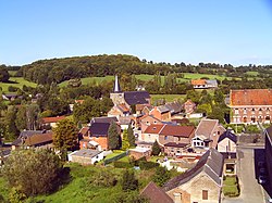
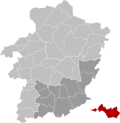
Voeren (Dutch pronunciation: [ˈvuːrə(n)] ⓘ; French: Fourons [fuʁɔ̃]) is a Flemish Dutch-speaking municipality with facilities for the French-speaking minority, located in the Belgian province of Limburg. Bordering the Netherlands to the north and the Wallonia region's Liège Province (Dutch: Luik) to the south, it is geographically detached from the rest of Flanders, making Voeren an exclave of Flanders. Voeren's name is derived from that of a small right-bank tributary of the Meuse, the Voer, which flows through the municipality.
The current municipality of Voeren was established by the municipal reform of 1977. On 1 January 2008, Voeren had a total population of 4,207. Its total area is 50.63 km2 (19.55 sq mi), giving a population density of 83 inhabitants per square kilometre (210/sq mi). About 25% of the population is made up of foreign nationals, most of whom have Dutch nationality.
- ^ "Wettelijke Bevolking per gemeente op 1 januari 2018". Statbel. Retrieved 9 March 2019.


