Waimea Plains | |
|---|---|
Locality | |
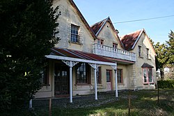
 The Gables on Waimea West Road | |
 | |
| Coordinates: 41°20′S 173°08′E / 41.333°S 173.133°E | |
| Country | New Zealand |
| Territorial authority | Tasman |
| Ward | Moutere-Waimea Ward |
| Electorates | |
| Government | |
| • Territorial Authority | Tasman District Council |
| • Mayor of Tasman | Tim King |
| • West Coast-Tasman MP | Maureen Pugh |
| • Te Tai Tonga MP | Tākuta Ferris |
| Area | |
• Total | 60.07 km2 (23.19 sq mi) |
| Population (June 2024)[2] | |
• Total | 1,230 |
| • Density | 20/km2 (53/sq mi) |
| Time zone | UTC+12 (NZST) |
| • Summer (DST) | UTC+13 (NZDT) |
| Area code | 03 |
The Waimea Plains is a small but fertile area of low-lying land southwest of the port city of Nelson, situated on Tasman Bay / Te Tai-o-Aorere in the South Island of New Zealand. It is irrigated by the Waimea River from the Waimea Inlet in the north and bounded by the town of Brightwater in the south.[3] The fertile soil promotes the growth of kiwifruit, apples and vineyards.[4]
The temperate climate allows for the growth of crops such as hops and grapes.
- ^ Cite error: The named reference
Areawas invoked but never defined (see the help page). - ^ "Aotearoa Data Explorer". Statistics New Zealand. Retrieved 26 October 2024.
- ^ Te Ara – The Encyclopedia of New Zealand, Carl Walrond, 22 April 2015
- ^ Page 3. Richmond and the Waimea Plains, Te Ara – The Encyclopedia of New Zealand, Carl Walrond, published 7 September 2010, updated 22 April 2015, retrieved 8 April 2018
