Back Prefektur Wakayama ACE Wakayama-prefektuur Afrikaans واكاياما (محافظة) Arabic Vakayama prefekturası Azerbaijani واکایاما اوستانی AZB Préféktur Wakayama BAN Вакаяма (прэфектура) Byelorussian Вакаяма (префектура) Bulgarian ওয়াকায়ামা প্রশাসনিক অঞ্চল Bengali/Bangla Prefectura de Wakayama Catalan
Wakayama Prefecture
和歌山県 | |
|---|---|
| Japanese transcription(s) | |
| • Japanese | 和歌山県 |
| • Rōmaji | Wakayama-ken |
| Anthem: Wakayama kenminka | |
 | |
| Country | Japan |
| Region | Kansai |
| Island | Honshū |
| Capital | Wakayama (city) |
| Subdivisions | Districts: 6, Municipalities: 30 |
| Government | |
| • Governor | Shūhei Kishimoto (since December 17, 2022) |
| Area | |
• Total | 4,724.69 km2 (1,824.21 sq mi) |
| • Rank | 30th |
| Population (1 October 2017) | |
• Total | 944,320 |
| • Rank | 39th |
| • Density | 199.87/km2 (517.7/sq mi) |
| • Dialects | Kishū |
| GDP | |
| • Total | JP¥ 3,745 billion US$ 34.4 billion (2019) |
| ISO 3166 code | JP-30 |
| Website | www.wakayama.lg.jp/ english/ |
| Symbols of Japan | |
| Bird | Japanese white-eye (Zosterops japonica) |
| Flower | Ume blossom (Prunus mume) |
| Tree | Ubame oak (Quercus phillyraeoides) |
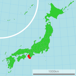
Wakayama Prefecture (和歌山県, Wakayama-ken) is a prefecture of Japan located in the Kansai region of Honshu.[2]: 1026 Wakayama Prefecture has a population of 944,320 (as of 1 October 2017[update]) and has a geographic area of 4,724 square kilometres (1,824 sq mi). Wakayama Prefecture borders Osaka Prefecture to the north, and Mie Prefecture and Nara Prefecture to the northeast.
Wakayama is the capital and largest city of Wakayama Prefecture, with other major cities including Tanabe, Hashimoto, and Kinokawa.[3]: 1025 Wakayama Prefecture is located on the southwestern coast of the Kii Peninsula on the Kii Channel, connecting the Pacific Ocean and Seto Inland Sea, across from Tokushima Prefecture on the island of Shikoku.
- ^ "2020年度国民経済計算(2015年基準・2008SNA) : 経済社会総合研究所 - 内閣府". 内閣府ホームページ (in Japanese). Retrieved 2023-05-18.
- ^ Nussbaum, Louis-Frédéric. (2005). "Wakayama prefecture" in Japan Encyclopedia, p. 1026, p. 1026, at Google Books; "Kansai" in p. 477, p. 477, at Google Books.
- ^ Nussbaum, "Wakayama" in p. 1025, p. 1025, at Google Books.


