Back Walgett (rehiyon) CEB Walgett Shire German Comté de Walgett French Contea di Walgett Italian Walgett Shire Council Dutch Walgett Shire Swedish 沃爾格特郡 Chinese
| Walgett Shire New South Wales | |||||||||||||||
|---|---|---|---|---|---|---|---|---|---|---|---|---|---|---|---|
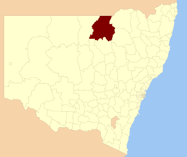
 Location in New South Wales | |||||||||||||||
| Coordinates | 30°01′S 148°07′E / 30.017°S 148.117°E | ||||||||||||||
| Population |
| ||||||||||||||
| • Density | 0.273415/km2 (0.70814/sq mi) | ||||||||||||||
| Established | 7 March 1906 | ||||||||||||||
| Area | 22,336 km2 (8,624.0 sq mi) | ||||||||||||||
| Mayor | Jasen Ramien (Unaligned) | ||||||||||||||
| Council seat | Walgett | ||||||||||||||
| Region | Orana | ||||||||||||||
| State electorate(s) | Barwon | ||||||||||||||
| Federal division(s) | Parkes | ||||||||||||||
 | |||||||||||||||
| Website | Walgett Shire | ||||||||||||||
| |||||||||||||||
Walgett Shire is a local government area in the Orana region of New South Wales, Australia. The northern boundary of the Shire is located adjacent to the border between New South Wales and Queensland. The town of Walgett is located on the Namoi River, nearby to its junction with the Barwon River and at the junction of the Kamilaroi Highway and the Castlereagh Highway.
The Shire is divided between the agricultural areas (producing wool, cattle, wheat and cotton), which are near the Barwon and Namoi rivers or south-east of the Barwon River, and the outback country north-west of the Barwon River, including the black opal mining and fossicking town of Lightning Ridge. Prior to 1957, when Lightning Ridge was established as a significant settlement, the outback country was part of the Western Division.
The mayor of Walgett Shire Council is Jasen Ramien who is unaligned with any political party.[3]
- ^ Australian Bureau of Statistics (27 June 2017). "Walgett (A)". 2016 Census QuickStats. Retrieved 7 July 2017.
- ^ "3218.0 – Regional Population Growth, Australia, 2017–18". Australian Bureau of Statistics. 27 March 2019. Archived from the original on 27 March 2019. Estimated resident population (ERP) at 30 June 2018.
- ^ "Profiles" (PDF). Walgett shire Council. Archived (PDF) from the original on 24 March 2019. Retrieved 21 April 2019.