Back ওয়াশিংটন মেট্রো Bengali/Bangla Metro de Washington Catalan Metro ve Washingtonu Czech Washington Metro Danish Metro Washington German Metroo de Vaŝingtono Esperanto Metro de Washington Spanish Washingtoni metroo Estonian Washingtongo metroa Basque متروی واشینگتن Persian
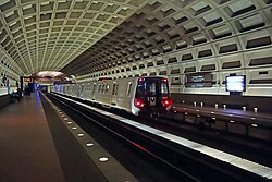
The Washington Metro, often abbreviated as the Metro and formally the Metrorail,[4] is a rapid transit system serving the Washington metropolitan area of the United States. It is administered by the Washington Metropolitan Area Transit Authority (WMATA), which also operates the Metrobus service under the Metro name.[5] Opened in 1976, the network now includes six lines, 98 stations, and 129 miles (208 km) of route.[6][7]
Metro serves Washington, D.C. and the states of Maryland and Virginia. In Maryland, Metro provides service to Montgomery and Prince George's counties; in Virginia, to Arlington, Fairfax and Loudoun counties, and to the independent city of Alexandria. The system's most recent expansion, which is the construction of a new station (and altering the line), serving Potomac Yard, opened on May 19, 2023. It operates mostly as a deep-level subway in more densely populated parts of the D.C. metropolitan area (including most of the District itself), while most of the suburban tracks are at surface level or elevated. The longest single-tier escalator in the Western Hemisphere, spanning 230 feet (70 m), is located at Metro's deep-level Wheaton station.[8]
In 2023, the system had a ridership of 136,303,200, or about 450,600 per weekday as of the third quarter of 2024, making it the second-busiest heavy rail rapid transit system in the United States, in number of passenger trips, after the New York City Subway, and the sixth-busiest in North America.[9] In June 2008, Metro set a monthly ridership record with 19,729,641 trips, or 798,456 per weekday.[10] Fares vary based on the distance traveled, the time of day, and the type of card used by the passenger. Riders enter and exit the system using a proximity card called SmarTrip.
- ^ "Transit Ridership Report Third Quarter 2024" (PDF). American Public Transportation Association. November 20, 2024. Retrieved November 23, 2024.
- ^ "Transit Ridership Report Fourth Quarter 2023" (PDF). American Public Transportation Association. March 4, 2024. Retrieved September 5, 2024.
- ^ a b "WMATA Summary – Level Rail Car Performance For Design And Simulation" (PDF). Washington Metropolitan Area Transit Authority. October 13, 2013. Archived from the original (PDF) on February 9, 2014. Retrieved October 15, 2014.
- ^ Schrag, Zachary (2006). "Introduction". The Great Society Subway: A History of the Washington Metro. Baltimore, Maryland: The Johns Hopkins University Press. p. 9. ISBN 0-8018-8246-X.Google Books search/preview Archived November 18, 2016, at the Wayback Machine
- ^ "Questions & Answers About Metro". Washington Metropolitan Area Transit Authority. 2017. Archived from the original on February 2, 2017. Retrieved January 20, 2017.
What do I need to know to build near Metro property? Metro reviews designs and monitors construction of projects adjacent to Metrorail and Metrobus property...
- ^ "History". Washington Metropolitan Area Transit Authority. 2017. Archived from the original on January 26, 2017. Retrieved January 20, 2017.
- ^ "Metro launches Silver Line, largest expansion of region's rail system in more than two decades" (Press release). Washington Metropolitan Area Transit Authority. July 25, 2014. Archived from the original on June 18, 2016. Retrieved January 20, 2017.
- ^ "Metro Facts 2018" (PDF). WMATA. Archived (PDF) from the original on July 11, 2019. Retrieved November 14, 2019.
- ^ "With soaring Metro, DC Streetcar, and VRE ridership, Washington region leads transit recovery in US". Greater Greater Washington. July 6, 2023. Retrieved July 6, 2023.
- ^ "215 million people rode Metro in fiscal year 2008". Washington Metropolitan Area Transit Authority. July 8, 2008. Archived from the original on February 2, 2017. Retrieved January 20, 2017.


