Back واتسون ایسلند AZB Watson Island (pulo sa Tinipong Bansa, Florida, Miami-Dade County) CEB Isla Watson (Miami) Spanish Watson Island French جزیرہ واٹسن (میامی) Urdu
Watson Island | |
|---|---|
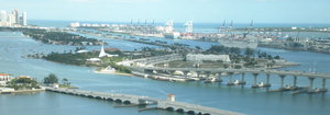
 Watson Island and the MacArthur Causeway, with the Venetian Causeway in the foreground | |
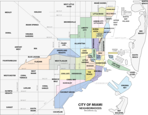
 Map of Miami neighborhoods. Watson Island is the smallest light-blue area, just above the western end of the elongated green Port of Miami area. | |
| Country | United States |
| State | Florida |
| County | Miami-Dade County |
| City | Miami |
| Government | |
| • City of Miami Commissioner | Marc Sarnoff |
| • Miami-Dade County Commissioners | Bruno Barreiro and Audrey Edmonson |
| • House of Representatives | Carlos Lopez-Cantera (R) and Luis García Jr. (R) |
| • State Senate | Gwen Margolis (D) |
| • U.S. House | Ileana Ros-Lehtinen (R) |
| Area | |
• Total | 0.280 sq mi (0.73 km2) |
| Time zone | UTC-05 (EST) |
| ZIP Code | 33132 |
| Area code(s) | 305, 786 |
Watson Island is a neighborhood and man-made island in Biscayne Bay, in Miami, Florida. It is located Immediately east of the Central Business District and Arts & Entertainment District neighborhoods of downtown Miami and is connected to the mainland and South Beach, Miami Beach by the MacArthur Causeway.