Back واوباكا Arabic واوباكا، ويسكونسين ARZ واپاکا، ویسکانسین AZB Waupaca Catalan Вопака (Висконсин) CE Waupaca CEB Waupaca German Waupaca (Wisconsin) Spanish Waupaca (Wisconsin) Basque واپاکا، ویسکانسین Persian
Waupaca, Wisconsin | |
|---|---|
 Waupaca City Hall/Library Building | |
 Location of Waupaca in Waupaca County, Wisconsin. | |
| Coordinates: 44°21′18″N 89°4′54″W / 44.35500°N 89.08167°W | |
| Country | United States |
| State | Wisconsin |
| County | Waupaca |
| Area | |
• Total | 8.21 sq mi (21.27 km2) |
| • Land | 7.92 sq mi (20.51 km2) |
| • Water | 0.29 sq mi (0.75 km2) |
| Population | |
• Total | 6,282 |
| • Density | 793.2/sq mi (306.3/km2) |
| Time zone | UTC-6 (Central (CST)) |
| • Summer (DST) | UTC-5 (CDT) |
| ZIP code | 54981 |
| Area code(s) | 715 & 534 |
| FIPS code | 55-84375 |
| Website | www.cityofwaupaca.org |


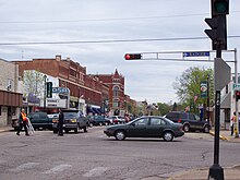
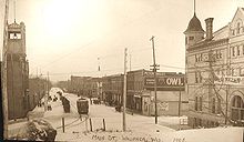
Waupaca (/wəˈpækə/ ⓘ wə-PAK-ə)[3] is a city in and the county seat of Waupaca County, Wisconsin, United States. The population was 6,282 at the 2020 census.[2]
The city is located mostly within the Town of Waupaca, and it is politically independent of the town. A portion extends west into the adjacent Town of Farmington, and there is also a noncontiguous area of the city in the Town of Lind to the south. The city is divided into natural areas, city areas, and industrial areas.
- ^ "2019 U.S. Gazetteer Files". United States Census Bureau. Retrieved August 7, 2020.
- ^ a b Cite error: The named reference
2020-census-5584375was invoked but never defined (see the help page). - ^ MissPronouncer.com: A HALFWAY DECENT AUDIO PRONUNCIATION GUIDE FOR WISCONSIN

