Back مقاطعة ويلد (كولورادو) Arabic Weld County, Colorado BAR Уэлд (акруга) Byelorussian Уелд Bulgarian ৱেল্ড কাউন্টি, কলোরাডো BPY Weld Gông (Colorado) CDO Уэлд (гуо, Колорадо) CE Weld County CEB Weld County Czech Weld County, Colorado Welsh
Weld County | |
|---|---|
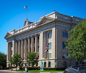
 Weld County Courthouse | |
 Location within the U.S. state of Colorado | |
 Colorado's location within the U.S. | |
| Coordinates: 40°32′N 104°24′W / 40.54°N 104.4°W | |
| Country | |
| State | |
| Founded | November 3, 1861 |
| Seat | Greeley |
| Largest city | Greeley |
| Area | |
• Total | 4,017 sq mi (10,400 km2) |
| • Land | 3,987 sq mi (10,330 km2) |
| • Water | 30 sq mi (80 km2) 0.7% |
| Population (2020) | |
• Total | 328,981 |
| • Density | 83/sq mi (32/km2) |
| Time zone | UTC−7 (Mountain) |
| • Summer (DST) | UTC−6 (MDT) |
| Congressional districts | 2nd, 4th, 8th |
| Website | www |
Weld County is a county located in the U.S. state of Colorado. As of the 2020 census, the population was 328,981.[1] The county seat is Greeley.[2]
Weld County comprises the Greeley, CO Metropolitan Statistical Area, which is included in the Denver–Aurora, CO Combined Statistical Area.[3]
- ^ "State & County QuickFacts". United States Census Bureau. Retrieved September 5, 2021.
- ^ "Find a County". National Association of Counties. Retrieved June 7, 2011.
- ^ "OMB Bulletin No. 10-02: Update of Statistical Area Definitions and Guidance on Their Uses" (PDF). Office of Management and Budget. December 1, 2009. Archived (PDF) from the original on January 21, 2017. Retrieved April 19, 2012 – via National Archives.