Back Уэст-Мідлендс (гарадская агламерацыя) Byelorussian وست میدلندز کانابیشن Persian Vakarų Midlandso konurbacija Lithuanian Conurbação de Midlands Ocidentais Portuguese Уэст-Мидлендс (городская агломерация) Russian Wast Midlands conurbation SCO Midlandton Serbo-Croatian West Midlands (tätort) Swedish Вест Мідлендс (міська агломерація) Ukrainian Chùm đô thị West Midlands Vietnamese
West Midlands
| |
|---|---|
| |
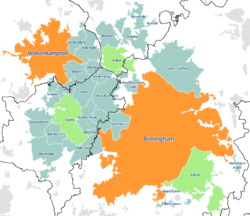
 Map of the West Midlands conurbation in 2011, with Travel to Work Areas overlaid. The five most populous are highlighted with Birmingham and Wolverhampton sub-divisions in orange and the Dudley, Walsall and Solihull sub-divisions in green. | |
| Sovereign state | United Kingdom |
| Constituent country | England |
| Largest settlements | (Pop. 100,000+) |
| Population | |
• Total | 2,440,986 |
| • Rank | 3rd |
| Time zone | UTC+0 (GMT) |
| • Summer (DST) | UTC+1 (BST) |
| Postcode | |
| Area code(s) | 0121, 01543, 01562, 01384, 01902, 01922 |
The West Midlands conurbation is the large conurbation in the West Midlands region of England. The area consists of two cities and numerous towns: to the east, the city of Birmingham, along with adjacent towns of Solihull and Sutton Coldfield; and to the west, the city of Wolverhampton and the area called the Black Country, containing the towns of Dudley, Walsall, West Bromwich, Oldbury, Willenhall, Bilston, Darlaston, Tipton, Smethwick, Wednesbury, Rowley Regis, Stourbridge and Halesowen.
It is broken down into multiple Travel to Work Areas: Birmingham, Wolverhampton, Dudley & Sandwell, Walsall & Cannock, Hagley is within the Kidderminster area and the extreme south-east corner is within the Warwick & Stratford upon Avon area. The conurbation is mainly in the West Midlands county, including parts of the surrounding counties of Staffordshire (e.g. Little Aston, Perton and Essington) and Worcestershire (such as Hagley and Hollywood), with Coventry a separate area in the county.
According to the 2011 Census the area had a population of 2,440,986,[1] making it the third most populated in the United Kingdom behind Greater London and Greater Manchester.
With the West Midlands also being a region and county, the conurbation is sometimes known as Birmingham-Wolverhampton.[2][3][4][5][6] though it is the term Birmingham & The Black Country that has gained the widest traction as an alternative to the conurbation's official name: an example of this is the tagline used by BBC Radio WM - "The sound of Birmingham & The Black Country".[7][8]
- ^ "2011 Census - Built-up areas". ONS. Retrieved 4 July 2013.
- ^ Fothergill, Stephen; Gudgin, Graham (1985), "Ideology and methods in industrial location research", in Massey, Doreen; Meegan, Richard (eds.), Politics and Method: Contrasting Studies in Industrial Geography, London: Taylor & Francis, p. 89, ISBN 978-0203974551, retrieved 6 October 2013
- ^ 143 (West Midlands) Brigade, British Army, 2013, retrieved 6 October 2013
- ^ Goode, David (2010), "Planning for Nature in Towns and Cities", in Douglas, Ian; Goode, David; Houck, Mike; Wang, Rusong (eds.), The Routledge Handbook of Urban Ecology, London: Routledge, p. 86, ISBN 978-0203839263, retrieved 6 October 2013
- ^ Wells, John C. (1982), "Accents of English 2: The British Isles", Accents of English 2: The British Isles, Cambridge: Cambridge University Press, p. 350, ISBN 978-0521285407, retrieved 9 October 2013
- ^ Way, J.M. (1976), Grassed and Planted Areas by Motorways (PDF), Huntingdon: The Institute of Terrestrial Ecology, p. 8, ISBN 978-0521285407, retrieved 9 October 2013
- ^ Wise, M.J. (1972), "The Birmingham-Black Country Conurbation in its Regional Setting", Geography Vol 57, number 2, vol. 57, Geographical Association, pp. 89–104, JSTOR 40568059
- ^ Whitehead, Mark (2007), Spaces of Sustainability: Geographical Perspectives on the Sustainable Society, Routledge, p. 155, ISBN 978-0203004098, retrieved 6 October 2013


