Back ويست بوينت، نيو يورك ARZ وست پوینت، نیویورک AZB Уест Пойнт Bulgarian West Point (Nova York) Catalan West Point (lungsod sa Tinipong Bansa, New York, Orange County) CEB West Point (New York) German West Point (Nueva York) Spanish West Point (New York) Basque وست پوینت، نیویورک Persian West Point (New York) French
West Point, New York | |
|---|---|
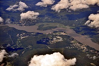
 Aerial view of West Point (at the center), the Hudson River, Highland Falls (on right), Cold Spring (on left) across the river in Putnam County | |
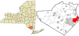
 Location of West Point in Orange County, New York (right) and of Orange County in New York state (left) | |
| Coordinates: 41°23′42″N 73°57′18″W / 41.39500°N 73.95500°W | |
| Country | United States |
| State | New York |
| County | Orange |
| Town | Highlands |
| Area | |
• Total | 19.34 sq mi (50.08 km2) |
| • Land | 18.43 sq mi (47.75 km2) |
| • Water | 0.90 sq mi (2.33 km2) |
| Population (2020) | |
• Total | 7,341 |
| • Density | 398.21/sq mi (153.75/km2) |
| Time zone | UTC−5 (Eastern (EST)) |
| • Summer (DST) | UTC−4 (EDT) |
| ZIP Codes | 10996–10997 |
| Area code | 845 |
| FIPS code | 36-80747[2] |
West Point is the oldest continuously occupied military post in the United States. Located on the Hudson River in New York, General George Washington stationed his headquarters in West Point in the summer and fall of 1779 during the American Revolutionary War, and later called it "the most important Post in America" in 1781 following the war's end. West Point also was the site of General Benedict Arnold's failed attempt at treason during the Revolutionary War.
West Point was first occupied by the United States Armed Forces in January 1778 by Brigadier General Samuel Holden Parsons. Since, West Point has been occupied by the United States Army. It comprises 25.1 sq mi (65 km2) land and water including the campus of the United States Military Academy, which is commonly referred to as "West Point".
West Point is a census-designated place (CDP) located in the town of Highlands in Orange County, located on the western bank of the Hudson River. The population was 7,341 at the 2020 census. It is part of the New York–Newark–Jersey City, NY–NJ–PA Metropolitan Statistical Area as well as the larger New York–Newark, NY–NJ–CT–PA Combined Statistical Area.
- ^ "ArcGIS REST Services Directory". United States Census Bureau. Archived from the original on January 19, 2022. Retrieved September 20, 2022.
- ^ "U.S. Census website". United States Census Bureau. Archived from the original on December 27, 1996. Retrieved January 31, 2008.
