Back Riding Gorllewinol Swydd Efrog Welsh West Riding of Yorkshire German West Riding of Yorkshire French West Riding of Yorkshire ID West Riding of Yorkshire Italian West Riding of Yorkshire NB West Riding of Yorkshire Polish West Riding of Yorkshire Portuguese Западный райдинг Йоркшира Russian West Riding of Yorkshire SIMPLE
| County of York, West Riding | |
|---|---|
 Flag of West Riding (2013) | |
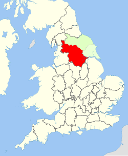
 1888–1974: County of York in England: West Riding (red), North Riding (light green), and East Riding (very pale green) | |
| Area | |
| • 1911 | 1,685,409 acres (6,820.61 km2) |
| • 1961 | 1,621,068 acres (6,560.23 km2) |
| Population | |
| • 1901 | 1,538,572 |
| History | |
| • Created |
|
| • Abolished |
|
| • Succeeded by | |
| Status | Ancient riding, then administrative county |
| Chapman code | WRY |
| Government | |
| • HQ | Wakefield |
| • Motto | Audi consilium (Heed counsel)[1] |
 Coat of arms of West Riding County Council | |
The West Riding of Yorkshire was one of three historic subdivisions of Yorkshire, England. From 1889 to 1974 the riding was an administrative county named County of York, West Riding. The lieutenancy at that time included the city of York and as such was named "West Riding of the County of York and the County of the City of York".[2] The riding ceased to be used for administrative purposes in 1974, when England's local government was reformed.
Contemporary local government boundaries in Yorkshire largely do not follow those of the riding. All of South Yorkshire (except Finningley) and West Yorkshire were historically within its boundaries, as were the south-western areas of North Yorkshire (including Ripon), the Sedbergh area of Cumbria, the Barnoldswick and Slaidburn areas of Lancashire, the Saddleworth area of Greater Manchester and the part of the East Riding of Yorkshire around Goole and southwest of the River Ouse.
- ^ "Civic Heraldry of England and Wales - Yorkshire, West Riding (Obsolete)". Civicheraldry.co.uk.
- ^ Lewis, Samuel A topographical dictionary of England (Vol. IV, p. 618) S. Lewis & Co., London: 1831.