Back Западен Йоркшър (метрополис) Bulgarian Wilayah Perkotaan West Yorkshire ID Área urbana de West Yorkshire Portuguese Западный Йоркшир (городская агломерация) Russian Wast Yorkshire Urban Aurie SCO Західний Йоркшир (міська агломерація) Ukrainian Vùng đô thị West Yorkshire Vietnamese 西約克郡都市區 Chinese
| West Yorkshire Built-up Area | |
|---|---|
| Conurbation | |
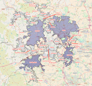
 2011 map of the West Yorkshire Built-up Area, showing subdivisions | |
| Area | 487.8 km2 (188.3 sq mi) |
| Population | 1,777,934 |
| • Density | 3,645/km2 (9,440/sq mi) |
| OS grid reference | SE455215 |
| Metropolitan county | |
| Region | |
| Country | England |
| Sovereign state | United Kingdom |
| Police | West Yorkshire |
| Fire | West Yorkshire |
| Ambulance | Yorkshire |
The West Yorkshire Built-up Area, previously known as the West Yorkshire Urban Area, is a term used by the Office for National Statistics (ONS) to refer to a conurbation in West Yorkshire, England, based on the cities of Leeds, Bradford and Wakefield, and the large towns of Huddersfield and Halifax. It is the fourth largest urban area in the United Kingdom. However, it excludes other towns and villages such as Featherstone, Normanton, Castleford, Pontefract, Hemsworth, Todmorden, Hebden Bridge, Knottingley, Wetherby and Garforth which, though part of the county of West Yorkshire, are considered independently. There are substantial areas of agricultural land within the designated area – more than in any other official urban area in England – many of the towns and cities are only just connected by narrow outlying strips of development.


