Back Westdorp CEB وستدورپ Persian Westdorp French Westdorp (Drenthe) Dutch Westdorp Polish Westdorp Portuguese Вестдорп Ukrainian Westdorp ZH-MIN-NAN
Westdorp | |
|---|---|
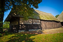
 Farm in Westdorp | |
 The village (dark red) and the statistical district (light green) of Westdorp in the municipality of Borger-Odoorn. | |
Location of the village in the province of Drenthe | |
| Coordinates: 52°54′N 6°46′E / 52.900°N 6.767°E | |
| Country | Netherlands |
| Province | Drenthe |
| Municipality | Borger-Odoorn |
| Area | |
• Total | 6.09 km2 (2.35 sq mi) |
| Elevation | 15 m (49 ft) |
| Population (2021)[1] | |
• Total | 135 |
| • Density | 22/km2 (57/sq mi) |
| Time zone | UTC+1 (CET) |
| • Summer (DST) | UTC+2 (CEST) |
| Postal code | 9534[1] |
| Dialing code | 0591 |
Westdorp is a village in the Dutch province of Drenthe. It is a part of the municipality of Borger-Odoorn, and lies about 17 km northwest of Emmen.
- ^ a b c "Kerncijfers wijken en buurten 2021". Central Bureau of Statistics. Retrieved 11 April 2022.
- ^ "Postcodetool for 9534PA". Actueel Hoogtebestand Nederland (in Dutch). Het Waterschapshuis. Retrieved 11 April 2022.

