Back West-Neuguinea ALS غرب غينيا الجديدة Arabic Nueva Guinea Occidental AST Papua (wawidangan Indonésia) BAN Западна Нова Гвинея Bulgarian Papoua ar C'hornaoueg Breton Papua Occidental Catalan Západní Nová Guinea Czech Westneuguinea German Okcidenta Nov-Gvineo Esperanto
Western New Guinea
Papua West Irian / Irian Jaya / West Papua / Dutch New Guinea | |
|---|---|
 | |
| Country | Indonesia |
| Provinces | |
| Largest cities | |
| Area | |
• Total | 412,214.61 km2 (159,156.95 sq mi) |
| Population (mid 2022 estimate)[1] | |
• Total | 5,601,888 |
| • Density | 14/km2 (35/sq mi) |
| Time zone | UTC+09:00 (Indonesia Eastern Time) |
| ISO 3166-2 | ID-PP[2] |
| Vehicle registration plates |
|
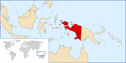
Western New Guinea, also known as Papua, Indonesian New Guinea, and Indonesian Papua,[3] is the western half of the island of New Guinea, formerly Dutch and granted to Indonesia in 1962. Given the island is alternatively named Papua, the region is also called West Papua (Indonesian: Papua Barat).[4]
Lying to the west of Papua New Guinea and geographically a part of the Australian continent, the territory is almost entirely in the Southern Hemisphere and includes the Biak and Raja Ampat archipelagoes. The region is predominantly covered with rainforest where traditional peoples live, including the Dani of the Baliem Valley. A large proportion of the population live in or near coastal areas. The largest city is Jayapura.
In the late 1940s, territories of the Dutch East Indies became the independent country of Indonesia, except Western New Guinea. The Dutch retained sovereignty over Western New Guinea (Dutch New Guinea) until the New York Agreement on 15 August 1962, which granted the region to Indonesia. The region became the province of Irian Barat (West Irian) before being renamed Irian Jaya (literally "Glorious Irian") in 1973 and Papua in 2002.[5] The following year, a second province was created from the western part of Papua Province; this was called West Papua, with its administrative capital as Manokwari. Both provinces were granted special autonomous status by Indonesian legislation.[6] In November 2022 three additional provinces were created from parts of Papua Province – Central Papua, Highland Papua, and South Papua – while another additional province, Southwest Papua, was created from part of West Papua Province; these received the same special autonomous status as (the residual) West Papua and Papua Provinces, the latter now reduced to northern Papua and the groups of islands in Cenderawasih Bay.
In 2020, West Papua and Papua provinces had a census population of 5,437,775, the majority of whom are indigenous;[7] the official estimate as of mid-2022 was 5,601,888.[1]
The official language is Indonesian, with Papuan Malay the most used lingua franca.[8] Estimates of the number of local languages in the region range from 200 to over 700, with the most widely spoken including Dani, Yali, Ekari and Biak.[9] The predominant official religion is Christianity, followed by Islam. The main industries include agriculture, fishing, oil production, and mining.[citation needed]
- ^ a b Badan Pusat Statistik, Jakarta, 2023.
- ^ "Indonesia Provinces". www.statoids.com.
- ^ "Indonesian Papua: A Local Perspective on the Conflict". International Crisis Group. 2007. Retrieved 23 April 2021.
- ^ Saltford, J. (2003). The United Nations and the Indonesian Takeover of West Papua, 1962–1969: the anatomy of betrayal (1st ed.). London: Routledge.
- ^ "Papua". Encyclopædia Britannica. Retrieved 3 November 2020.
- ^ "UU No. 2 Tahun 2021". Database Peraturan | JDIH BPK. Retrieved 19 October 2024.
- ^ "BPS Provinsi Papua Barat".
- ^ Kluge 2014, p. 2.
- ^ HOWARD, Michael C. (2000). "Dress and Ethnic Identity in Irian Jaya". Sojourn: Journal of Social Issues in Southeast Asia. 15 (1): 1–29. doi:10.1355/SJ15-1A. ISSN 0217-9520. JSTOR 41057027.