Back وايت هاوس ستيشن (نيوجيرسي) Arabic وايت هاوس ستيشن ARZ وایتهاوس، استیشن، نیوجرسی AZB White House Station Catalan Whitehouse Station CEB Whitehouse Station Spanish وایتهاوس، استیشن، نیوجرسی Persian وایت هاوس استیشن (نيۊجرسي) GLK Whitehouse Station Italian Уайтхаус Стэйшн (Нью-Джерси) Kazakh
Whitehouse Station, New Jersey | |
|---|---|
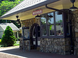
 Whitehouse Train Station & Readington Library | |
 Map of Whitehouse Station highlighted within Hunterdon County. Right: Location of Hunterdon County in New Jersey. | |
Location in Hunterdon County Location in New Jersey | |
| Coordinates: 40°36′55″N 74°46′14″W / 40.61528°N 74.77056°W[1] | |
| Country | |
| State | |
| County | Hunterdon |
| Township | Readington |
| Area | |
• Total | 2.57 sq mi (6.65 km2) |
| • Land | 2.52 sq mi (6.52 km2) |
| • Water | 0.05 sq mi (0.13 km2) 3.20% |
| Elevation | 174 ft (53 m) |
| Population | |
• Total | 3,152 |
| • Density | 1,251.29/sq mi (483.14/km2) |
| Time zone | UTC−05:00 (Eastern (EST)) |
| • Summer (DST) | UTC−04:00 (Eastern (EDT)) |
| ZIP Code | 08889[5] |
| Area code | 908 |
| FIPS code | 34-80720[6][7][8] |
| GNIS feature ID | 881799,[1] 2390505[3] |
Whitehouse Station, also spelled White House Station, is an unincorporated community and census-designated place (CDP) located within Readington Township, in Hunterdon County, New Jersey.[9][10] At the 2010 United States Census, the CDP's population was 2,089.[11] Whitehouse Station takes its name from Whitehouse and Abraham Van Horne's 18th century tavern.[12]
New Jersey Transit offers service on the Raritan Valley Line at White House Station.[13]
- ^ a b "Whitehouse Station". Geographic Names Information System. United States Geological Survey, United States Department of the Interior.
- ^ "ArcGIS REST Services Directory". United States Census Bureau. Retrieved October 11, 2022.
- ^ a b "White House Station Census Designated Place". Geographic Names Information System. United States Geological Survey, United States Department of the Interior.
- ^ Cite error: The named reference
USCensusDecennial2020CenPopScriptOnlywas invoked but never defined (see the help page). - ^ Look Up a ZIP Code for Whitehouse Station, NJ, United States Postal Service,. Accessed April 26, 2012.
- ^ Gazetteer of New Jersey Places, United States Census Bureau. Accessed July 21, 2016.
- ^ U.S. Census website, United States Census Bureau. Accessed September 4, 2014.
- ^ Geographic Codes Lookup for New Jersey, Missouri Census Data Center. Accessed June 9, 2023.
- ^ New Jersey: 2010 - Population and Housing Unit Counts - 2010 Census of Population and Housing (CPH-2-32), United States Census Bureau, August 2012. Accessed November 15, 2012.
- ^ Locality Search, State of New Jersey. Accessed April 19, 2015.
- ^ DP-1 - Profile of General Population and Housing Characteristics: 2010 Demographic Profile Data for White House Station CDP, New Jersey Archived 2020-02-12 at archive.today, United States Census Bureau. Accessed November 20, 2012.
- ^ Staff. "Living history in Whitehouse", Courier News, March 6, 2005. Accessed November 16, 2012. "About 1750 Abraham Van Horne built the first tavern in the area. It was on the road from Clinton to Somerville where it crossed Rockaway Creek (now Route 22). Because the building had white plastered walls it became known as the 'White House'. The name also was given to the village which sprang up around the tavern."
- ^ Hunterdon County Bus / Rail Connections, New Jersey Transit, backed up by the Internet Archive as of July 26, 2010. Accessed November 14, 2012.


