| Whitton | |
|---|---|
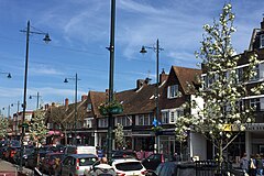
 The High Street | |
Location within Greater London | |
| Area | 3.56 km2 (1.37 sq mi) |
| Population | 20,065 (2011 Census Heathfield+Whitton 2011)[1][2] |
| • Density | 5,636/km2 (14,600/sq mi) |
| OS grid reference | TQ145735 |
| London borough | |
| Ceremonial county | Greater London |
| Region | |
| Country | England |
| Sovereign state | United Kingdom |
| Post town | TWICKENHAM |
| Postcode district | TW2 |
| Post town | HOUNSLOW |
| Postcode district | TW3, TW4 |
| Post town | ISLEWORTH |
| Postcode district | TW7 |
| Dialling code | 020 |
| Police | Metropolitan |
| Fire | London |
| Ambulance | London |
| UK Parliament | |
| London Assembly | |
Whitton is an area of the London Borough of Richmond upon Thames, England. Historically, it was the north-western part of Twickenham manor, bounded by the River Crane and the Duke of Northumberland's River.[3]
Whitton High Street is one of the best-preserved 1930s high streets in London. The most common type of housing in the area is 1930s detached and semi-detached housing. Whitton lies on the A316 road, which leads to the M3 motorway, and Whitton railway station is on the line from London Waterloo to Windsor. As a mainly residential area in outer London, many residents commute to Central London.
- ^ Census Information Scheme (2012). "2011 Census Ward Population figures for London". Greater London Authority. Retrieved 17 October 2023.
- ^ Key Statistics; Quick Statistics: Population Density Archived 11 February 2003 at the Wayback Machine United Kingdom Census 2011 Office for National Statistics Retrieved 20 December 2013
- ^ "Whitton | Hidden London".

