Back Wola Catalan Wola (lungsod sa Polskowa, Województwo Mazowieckie) CEB Wola Czech Wola (Warschau) German Wola (administra parto de Varsovio) Esperanto Wola Spanish Wola Estonian Wola (Varsovie) French וולה (ורשה) HE Wola Italian
Wola | |
|---|---|
 Rondo Daszyńskiego | |
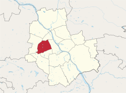
 Location of Wola within Warsaw | |
 Neighbourhoods of Wola | |
| Country | |
| Voivodeship | Masovian |
| County/City | Warsaw |
| Government | |
| • Mayor | Krzysztof Strzałkowski |
| Area | |
• Total | 19.26 km2 (7.44 sq mi) |
| Population (2019) | |
• Total | 140,958[1] |
| Time zone | UTC+1 (CET) |
| • Summer (DST) | UTC+2 (CEST) |
| Area code | +48 22 |
| Car plates | WY |
| Website | wola |
Wola (Polish pronunciation: [ˈvɔla] ⓘ) is a district in western Warsaw, Poland. An industrial area with traditions reaching back to the early 19th century, it underwent a transformation into a major financial district, featuring various landmarks and some of the tallest office buildings in the city.
- ^ "Powierzchnia i ludność w przekroju terytorialnym w 2019 roku. Tabl. 21 Powierzchnia, ludność oraz lokaty według gmi". stat.gov.pl. Główny Urząd Statystyczny. Archived from the original on 25 July 2019. Retrieved 2 September 2020.
