Back وودزید، کوینز AZB Woodside (Queens) Spanish Woodside (Queens) French Woodside (New York) Italian 우드사이드, 퀸스 Korean Woodside, Queens Turkish وڈسایڈ، کوئینز Urdu
Woodside | |
|---|---|
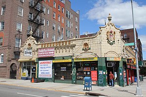
 Former Childs Restaurant branch at 60th Street and Queens Boulevard in Woodside | |
 Location within New York City | |
| Country | |
| State | |
| City | |
| County/Borough | |
| Community District | Queens 2[1] |
| Population | |
• Total | 45,099 |
| Ethnicity | |
| • Asian | 39.9% |
| • Hispanic | 33.5% |
| • White | 22.5% |
| • Black | 1.3% |
| • Other/Multiracial | 2.8% |
| Economics | |
| • Median income | $49,415 |
| Time zone | UTC−5 (EST) |
| • Summer (DST) | UTC−4 (EDT) |
| ZIP Code | 11377 |
| Area codes | 718, 347, 929, and 917 |
Woodside is a neighborhood in the western portion of the borough of Queens in New York City. It is bordered on the south by Maspeth, on the north by Astoria, on the west by Sunnyside, and on the east by Elmhurst, Jackson Heights, and East Elmhurst. Some areas are widely residential and very quiet, while other parts, especially the ones around Roosevelt Avenue, are busier.
In the 19th century the area was part of the Town of Newtown (now Elmhurst). The adjacent area of Winfield was largely incorporated into the post office serving Woodside and as a consequence Winfield lost much of its identity distinct from Woodside. However, with large-scale residential development in the 1860s, Woodside became the largest Irish American community in Queens, being approximately 80% Irish by the 1930s and maintaining a strong Irish culture today. In the early 1990s, many Asian American families include a large Filipino community moved into the area, and as a result the current population is 30% Asian American. South Asians and Latinos have also moved to Woodside in recent years.
Reflecting its longtime diverse cuisines, the neighborhood is filled with many cultural restaurants and pubs. It is also home to some of the city's most popular Thai, Filipino, and South American eateries.[4][5]
Woodside is located in Queens Community District 2 and its ZIP Code is 11377.[1] It is patrolled by the New York City Police Department's 108th Precinct.[6] Politically, Woodside is represented by the New York City Council's 22nd and 26th Districts.[7]
- ^ a b "NYC Planning | Community Profiles". communityprofiles.planning.nyc.gov. New York City Department of City Planning. Retrieved April 7, 2018.
- ^ Cite error: The named reference
PLP5was invoked but never defined (see the help page). - ^ Cite error: The named reference
PLP3Awas invoked but never defined (see the help page). - ^ Bruni, Frank (November 3, 2004). "A Thai Pilgrimage Leads to Queens". The New York Times. ISSN 0362-4331. Retrieved January 22, 2019.
- ^ Foggin, Mark (February 13, 2009). "Filipino "Soul Food" Comes to Queens". The New York Times. ISSN 0362-4331. Retrieved January 22, 2019.
- ^ Cite error: The named reference
NYPD 108th Precinctwas invoked but never defined (see the help page). - ^ Current City Council Districts for Queens County Archived December 22, 2016, at the Wayback Machine, New York City. Accessed May 5, 2017.