Back Worcester (Massachusetts) AN ورسستر Arabic ورسستر (ورسستر) ARZ ووستر، ماساچوست AZB Вустэр (Масачусетс) Byelorussian Устър (Масачузетс) Bulgarian উস্টার, ম্যাসাচুসেটস Bengali/Bangla Worcester (Massachusetts) Breton Worcester (Massachusetts) Catalan Вустер (Массачусетс) CE
Worcester, Massachusetts | |
|---|---|
City | |
| Nickname(s): The City of the Seven Hills, The Heart of the Commonwealth, Wormtown, Woo-town, The Woo | |
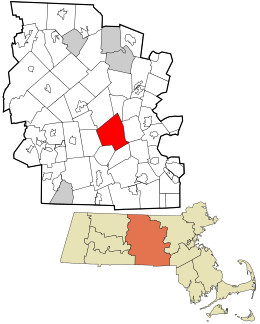
 Location within Worcester County | |
| Coordinates: 42°16′17″N 71°47′56″W / 42.27139°N 71.79889°W | |
| Country | United States |
| State | Massachusetts |
| County | Worcester |
| Region | New England |
| Historic colonies | Massachusetts Bay Colony Dominion of New England Province of Massachusetts Bay |
| Settled | 1673 |
| Incorporated as a town | June 14, 1722 |
| Incorporated as a city | February 29, 1848 |
| Named for | Worcester, Worcestershire |
| Government | |
| • Type | Council–manager |
| • City Manager | Eric D. Batista |
| • Mayor | Joseph Petty (D) |
| Area | |
• City | 38.44 sq mi (99.57 km2) |
| • Land | 37.36 sq mi (96.76 km2) |
| • Water | 1.08 sq mi (2.81 km2) |
| Elevation | 480 ft (146 m) |
| Population (2020) | |
• City | 206,518 (US: 114th) |
| • Density | 5,527.78/sq mi (2,134.27/km2) |
| • Urban | 482,085 (US: 87th) |
| • Urban density | 1,852.1/sq mi (715.1/km2) |
| • Metro | 862,111 (US: US: 69th) |
| Time zone | UTC−5 (Eastern) |
| • Summer (DST) | UTC−4 (Eastern) |
| ZIP Codes | 01601–01610, 01612–01615, 01653–01655 |
| Area code | 508 / 774 |
| FIPS code 0 | 25-82000 |
| GNIS feature ID | 0617867 |
| GDP | $45.393131 billion (as of 2018, in 2012 US chained dollars)[2] |
| GDP per capita | $45,528 per person[2][3] |
| Website | worcesterma |
Worcester (/ˈwʊstər/ ⓘ WUUST-ər, locally [ˈwɪstə] ⓘ)[4] is the second-most populous city in the U.S. state of Massachusetts and the 114th most populous city in the United States.[a][5] Named after Worcester, England, the city had 206,518 people at the 2020 census,[6] also making it the second-most populous city in New England, after Boston, Massachusetts. Worcester is about 40 miles (64 km) west of Boston, 50 miles (80 km) east of Springfield, Massachusetts, and 40 miles (64 km) north-northwest of Providence, Rhode Island. Because it is near the geographic center of Massachusetts, Worcester is known as the "Heart of the Commonwealth"; a heart is the official symbol of the city. Worcester is the historical seat of Worcester County.
Worcester developed as an industrial city in the 19th century because the Blackstone Canal and railways facilitated the import of raw materials and the export of such finished goods as machines, textiles, and wire. Many European immigrants made up the city's growing population. After World War II, manufacturing there waned; economic and population decline was not reversed until the 1990s, when higher education, medicine, biotechnology, and new immigrants started making their mark. The population has grown by 28% since 1980, reaching its all-time high in the 2020 census and effecting urban renewal.
Modern Worcester is known for its diversity and large immigrant population, with significant communities of Vietnamese, Brazilians, Albanians, Puerto Ricans, Ghanaians, Dominicans, and others.[7] Twenty-two percent of Worcester's population was born outside the United States.[8] A center of higher education, it is home to eight colleges and universities, including the College of the Holy Cross, Worcester Polytechnic Institute (WPI), and Clark University. Worcester has many 19th-century triple-decker houses, Victorian-era mills and related buildings, and lunch-car diners, such as Miss Worcester.
Worcester is the principal city of Central Massachusetts, and is a regional hub of government, industry, and transportation. Since the 1970s, and especially since the construction of Route 146 and interstates 90, 495, 190, 290, and 395, both Worcester and its surrounding towns have become more integrated with Boston's suburbs. The Worcester region now marks the western periphery of the Boston–Worcester–Providence (MA–RI–NH) U.S. Census Combined Statistical Area (CSA), or Greater Boston.
- ^ "2020 U.S. Gazetteer Files". United States Census Bureau. Retrieved May 21, 2022.
- ^ a b "Total Real Gross Domestic Product for Worcester, MA-CT (MSA)". Federal Reserve Bank of St. Louis. January 2001. Archived from the original on December 27, 2017. Retrieved November 25, 2020.
- ^ In 2012 chained US dollars. Calculated on the basis of the 2018 GDP figure, with the 2010 census-recorded population. Formula:
45.393131*10**9/181045. - ^ "How do you say 'Worcester?'". Archived from the original on May 4, 2015. Retrieved August 1, 2015.
- ^ "Annual Estimates of the Resident Population for Incorporated Places of 50,000 or More, Ranked by July 1, 2016 Population: April 1, 2010 to July 1, 2016—United States—Places of 50,000+ Population". 2016 Population Estimates. United States Census Bureau, Population Division. May 2017. Archived from the original on September 12, 2019. Retrieved July 12, 2017.
- ^ "Profile of General Population and Housing Characteristics: 2010 Demographic Profile Data (DP-1): Worcester city, Massachusetts". U.S. Census Bureau, American Factfinder. Archived from the original on February 12, 2020. Retrieved March 6, 2013.
- ^ Welker, Grant (November 12, 2018). "Coming to Worcester: The city's immigrant population has shifted in the last decade". Worcester Business Journal. Retrieved March 21, 2021.
- ^ Welker, Grant (November 12, 2018). "City of Immigrants: Foreign-born residents have unusually large impact on Worcester's economy". Worcester Business Journal. Retrieved March 21, 2021.
Cite error: There are <ref group=lower-alpha> tags or {{efn}} templates on this page, but the references will not show without a {{reflist|group=lower-alpha}} template or {{notelist}} template (see the help page).


