Back Wynberg Afrikaans Wynberg (bahin nga lungsod) CEB Wynberg German Wynberg French Wynberg Italian Wynberg NSO وینبرگ، کیپ ٹاؤن Urdu Wynberg Xhosa Wynberg Zulu
Wynberg | |
|---|---|
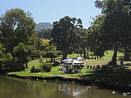
Clockwise from the top: Wynberg Park, Yusuffia mosque, Griffin House on Victoria Street, Number 2 Military Hospital at the Wynberg Military Base, and the Maynardville Park and Open-air Theater | |
 Street map of Wynberg | |
| Coordinates: 34°00′15″S 18°28′13″E / 34.00417°S 18.47028°E | |
| Country | South Africa |
| Province | Western Cape |
| Municipality | City of Cape Town |
| Main Place | Cape Town |
| Government | |
| • Councillor | Montgomery Oliver (DA) |
| Area | |
• Total | 5.06 km2 (1.95 sq mi) |
| Population (2011)[1] | |
• Total | 14,472 |
| • Density | 2,900/km2 (7,400/sq mi) |
| Racial makeup (2011) | |
| • Black African | 21.1% |
| • Coloured | 46.2% |
| • Indian/Asian | 3.6% |
| • White | 24.0% |
| • Other | 5.4% |
| First languages (2011) | |
| • English | 69.6% |
| • Afrikaans | 14.9% |
| • Xhosa | 5.0% |
| • Sotho | 1.1% |
| • Other | 9.4% |
| Time zone | UTC+2 (SAST) |
| Postal code (street) | 7800[2] |
| PO box | 7824 |
Wynberg (/ˈwaɪnbɜːrɡ/ WYNE-burg) is a southern suburb of the City of Cape Town in Western Cape, South Africa. It is situated between Plumstead and Kenilworth, and is a main transport hub for the Southern Suburbs of Cape Town.
- ^ a b c d "Sub Place Wynberg". Census 2011.
- ^ "Cape Postal Codes of South Africa". Post. Retrieved 15 April 2011.


