Back یارلونق تسانقپو چایی AZB यारलुंग त्सांग पो Bihari ཡར་ཀླུངས་གཙང་པོ་ Tibetan Jarlung Cangpo Esperanto Yarlung Tsangpo Spanish Yarlung Tsangpo French यरलुंग त्संगपो नदी Hindi Sungai Yarlung Tsangpo ID ヤルンツァンポ川 Japanese 얄룽창포강 Korean
| Yarlung Tsangpo yar klung gtsang po ཡར་ཀླུང་གཙང་པོ། 雅鲁藏布江 | |
|---|---|
 Yarlung Tsangpo, Shigatse Prefecture | |
 | |
| Location | |
| Country | China, India |
| Physical characteristics | |
| Source | |
| • location | Angsi Glacier in Shigatse, Tibet Autonomous Region, China |
| • coordinates | 30°23′N 82°0′E / 30.383°N 82.000°E |
| • elevation | 5,210 m (17,090 ft) |
| Mouth | |
• coordinates | 29°7′40.8036″N 95°1′19.8264″E / 29.128001000°N 95.022174000°E |
• elevation | 535 m (1,755 ft) |
| Length | 1,125 km (699 mi)[1] |
| Basin size | 241,691 km2 (93,317 sq mi)[2] |
| Discharge | |
| • average | 2,898.9 m3/s (102,370 cu ft/s)[2] |
| Basin features | |
| Tributaries | |
| • left | Raka Tsangpo, Nimu Maqu, Lhasa, Nyang |
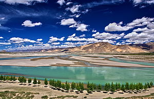
The Yarlung Tsangpo, also called Yarlung Zangbo (Tibetan: ཡར་ཀླུངས་གཙང་པོ་, Wylie: yar kLungs gTsang po, ZYPY: Yarlung Zangbo) and Yalu Zangbu River (Chinese: 雅鲁藏布江; pinyin: Yǎlǔzàngbù Jiāng) is a river that flows through the Tibet Autonomous Region of China and Arunachal Pradesh of India. It is the longest river of Tibet and the fifth longest in China.[3] The upper section is also called Dangque Zangbu meaning "Horse River".[4][5]
Originating from the Angsi Glacier in western Tibet, southeast of Mount Kailash and Lake Manasarovar, it later forms the South Tibet Valley and Yarlung Tsangpo Grand Canyon before passing into the state of Arunachal Pradesh in India. Downstream from Arunachal Pradesh, the river becomes far wider and is called the Siang. After reaching Assam, the river is known as the Brahmaputra.
When leaving the Tibetan Plateau, the river forms the world's largest and deepest canyon, Yarlung Tsangpo Grand Canyon.[6]
- ^ "YARLUNG TSANGPO (BRAHMAPUTRA RIVER) IN TIBET".
- ^ a b "Upper Brahmaputra".
- ^ Yue-man Yeung; Jianfa Shen (2004). Developing China's West: A Critical Path to Balanced National Development. Chinese University Press. p. 553. ISBN 978-9-62-996157-2.
- ^ Henry Strachey (1854). Physical Geography of Western Tibet, Part 24. W. Clowes. pp. 7–. OCLC 1063495284.
The river that carries the drainage of Nari-Mangyul and Utsang to the south-eastward is called by the Tibetans the rTachok Tsangspo, i.e. Horse River. The best of my Ladak informants could not assure me positively of its course below Lhasa, but assented fully to its identification with the main trunk of the Brahmaputra river, as asserted (and all but established) by the geographers of Bengal.
- ^ SHANTI (2016). "Brahmaputra River". University of Virginia. Retrieved 20 February 2022.
- ^ "The New largest Canyon in the world - The Great Canyon of Yalung Tsangpu River (Tibet)". www.100gogo.com. Archived from the original on 28 February 2008. Retrieved 19 July 2009.