Back مقاطعة ياتس (نيويورك) Arabic Yates County, New York BAR Йейтс (окръг) Bulgarian ইয়েটস কাউন্টি, নিউ ইয়র্ক BPY Yates Gông (New York) CDO Йейтс (гуо, Нью-Йорк) CE Yates County CEB Yates County Czech Yates County, Efrog Newydd Welsh Yates County German
Yates County | |
|---|---|
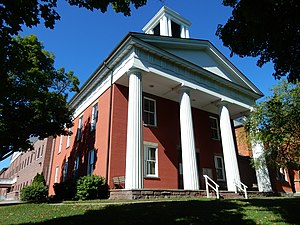
 Yates County Courthouse | |
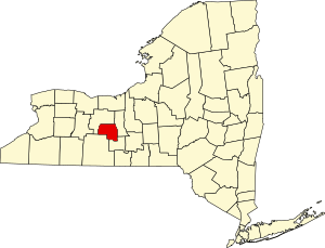
 Location within the U.S. state of New York | |
 New York's location within the U.S. | |
| Coordinates: 42°38′N 77°06′W / 42.64°N 77.1°W | |
| Country | |
| State | |
| Founded | February 5, 1823 |
| Named for | Joseph C. Yates |
| Seat | Penn Yan |
| Largest village | Penn Yan |
| Area | |
• Total | 376 sq mi (970 km2) |
| • Land | 338 sq mi (880 km2) |
| • Water | 38 sq mi (100 km2) 10% |
| Population (2020) | |
• Total | 24,774 [1] |
| • Density | 73.3/sq mi (28.3/km2) |
| Time zone | UTC−5 (Eastern) |
| • Summer (DST) | UTC−4 (EDT) |
| Congressional district | 23rd |
| Website | www |
Yates County is a county in the U.S. state of New York. As of the 2020 Census, the population was 24,774,[2] making it the third-least populous county in New York. The county seat is Penn Yan.[3] The name is in honor of Joseph C. Yates, who as Governor of New York signed the act establishing the county. The county is part of the Finger Lakes region of the state.
Yates County is included in the Rochester, NY Metropolitan Statistical Area.
- ^ "US Census 2020 Population Dataset Tables for New York". United States Census Bureau. Retrieved January 2, 2022.
- ^ "U.S. Census Bureau Quick Facts: Yates County, New York". United States Census Bureau. Retrieved January 2, 2022.
- ^ "Find a County". National Association of Counties. Archived from the original on May 31, 2011. Retrieved June 7, 2011.
