Back زاخارو Arabic زاخارو ARZ Захаро Bulgarian Zacháro CEB Zacharo Danish Zacharo German Ζαχάρω Greek Zajaro Spanish Zacháro Estonian زاخارو Persian
Zacharo
Ζαχάρω | |
|---|---|
 | |
| Coordinates: 37°29′N 21°39′E / 37.483°N 21.650°E | |
| Country | Greece |
| Administrative region | West Greece |
| Regional unit | Elis |
| Government | |
| • Mayor | Konstantinos Mitropoulos[1] (since 2023) |
| Area | |
• Municipality | 276.2 km2 (106.6 sq mi) |
| • Municipal unit | 187.0 km2 (72.2 sq mi) |
| Elevation | 33 m (108 ft) |
| Highest elevation | 1,345 m (4,413 ft) |
| Lowest elevation | 0 m (0 ft) |
| Population (2021)[2] | |
• Municipality | 8,654 |
| • Density | 31/km2 (81/sq mi) |
| • Municipal unit | 7,404 |
| • Municipal unit density | 40/km2 (100/sq mi) |
| • Community | 3,172 |
| Time zone | UTC+2 (EET) |
| • Summer (DST) | UTC+3 (EEST) |
| Postal code | 270 54 |
| Area code(s) | 26250 |
| Vehicle registration | ΗΑ |
| Website | www |
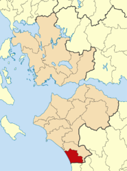
Zacharo (Greek: Ζαχάρω) is a town and municipality in western Peloponnese, Greece. Administratively, it belongs to the regional unit of Elis in West Greece. Zacharo is situated on the coast of the Gulf of Kyparissia, a part of the Ionian Sea. The mountain Lapithas is to the north, and the Minthi is to the east. Northwest of the town, between mount Lapithas and the sea, is the Kaiafas Lake. Zacharo is 18 km south of Olympia, 28 km southeast of Pyrgos, 65 km northwest of Kalamata and 65 km west of Tripoli. The town is crossed by the Greek National Road 9/E55, that links Patras with Kalamata.
- ^ Municipality of Zacharo, Municipal elections – October 2023, Ministry of Interior
- ^ "Αποτελέσματα Απογραφής Πληθυσμού - Κατοικιών 2021, Μόνιμος Πληθυσμός κατά οικισμό" [Results of the 2021 Population - Housing Census, Permanent population by settlement] (in Greek). Hellenic Statistical Authority. 29 March 2024.

