Back Propinsi Zambales ACE زامباله Arabic Sambales Azerbaijani زامباله AZB Zambales BCL Zambales CBK-ZAM Zambales CEB Zambales German Zambaloj Esperanto Zambales Spanish
Zambales | |
|---|---|
(from top: left to right) Zambales coastline, Zambales Provincial Capitol, Subic Bay, Zambales Mountains, and Subic Bay Economic Zone | |
| Nickname: Chromite Capital of the Philippines[1] | |
| Anthem: Himno ng Zambales English: Zambales Hymn Marcha Zambaleño English: March of the Zambaleans | |
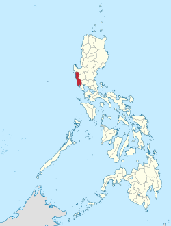
 Location within the Philippines | |
| Coordinates: 15°20′N 120°10′E / 15.33°N 120.17°E | |
| Country | Philippines |
| Region | Central Luzon |
| Founded | 1578 |
| Capital | Iba |
| Largest city | Olongapo |
| Government | |
| • Type | Sangguniang Panlalawigan |
| • Governor | Hermogenes E. Ebdane, Jr. (PFP) |
| • Vice Governor | Jacqueline Rose F. Khonghun (Aksyon) |
| • Legislature | Zambales Provincial Board |
| Area | |
• Total | 3,645.83 km2 (1,407.66 sq mi) |
| • Rank | 35th out of 81 |
| (excluding Olongapo City) | |
| Highest elevation | 2,037 m (6,683 ft) |
| Population (2020 census)[3] | |
• Total | 909,932 (including Olongapo City) |
| • Rank | 46th out of 81 |
| Demonyms |
|
| Divisions | |
| • Independent cities | 1
|
| • Component cities | 0 |
| • Municipalities | |
| • Barangays |
|
| • Districts | Legislative districts of Zambales (shared with Olongapo City) |
| Demographics | |
| • Ethnic groups | |
| • Languages | |
| • Major religions | |
| • Ecclesiastical dioceses | Diocese of Iba (Roman Catholic) Diocese of Zambales (Aglipayan Church) |
| • Patron saint | Our Lady of Poon Bato and Saint Augustine of Hippo |
| • Feast day | January 24 and August 28 respectively |
| Time zone | UTC+8 (PST) |
| IDD : area code | +63 (0)47 |
| ISO 3166 code | PH-ZMB |
| Website | www.zambales.gov.ph |
Zambales, officially the Province of Zambales (Sambal: Probinsya nin Zambales; Ilocano: Probinsia ti Zambales; Pangasinan: Luyag na Zambales Kapampangan: Lalawigan ning Zambales; Tagalog: Lalawigan ng Zambales), is a province in the Philippines located in the Central Luzon region. Its capital is Iba, which is located in the middle of the province. Olongapo is the largest city of the province wherein it is geographically located but politically independent.
Zambales borders Pangasinan to the north and northeast, Tarlac to the east, Pampanga to the southeast, Bataan to the south and the South China Sea to the west. With a total land area of 3,830.83 square kilometres (1,479.09 sq mi) (including the independent city of Olongapo), Zambales is the second largest among the seven provinces of Central Luzon after Nueva Ecija. The province is noted for its mangoes, which are abundant from January to April.
Zambales does not have a functional airport; the closest functional airport is Clark International Airport in Angeles City in the neighbouring province of Pampanga. Subic Bay International Airport, which is located in Cubi Point (geographically and politically located inside Morong, Bataan) in the Subic Bay Freeport Zone is no longer functional for domestic and international flights.[4]
The Freeport Zone (SBFZ) is host to many tourist attractions which include casinos, parks, malls, beach-side huts, cottages and resorts, as well as historical sites.
- ^ "Mining Firms Seek to Export Black Sand Thru Subic Port". Dean Alegado Reality. PIA Press Release. March 14, 2011. Retrieved March 23, 2016.
The miners told Salonga that Zambales was known before as the chromite capital of the Philippines, but with big developments in China today, magnetite iron ore has become more important than chromite.
- ^ "List of Provinces". PSGC Interactive. Makati, Philippines: National Statistical Coordination Board. Retrieved February 13, 2013.
- ^ Census of Population (2020). "Region III (Central Luzon)". Total Population by Province, City, Municipality and Barangay. Philippine Statistics Authority. Retrieved July 8, 2021.
- ^ Orejas, Tonnette (March 7, 2012). "It's more fun than an airport in Subic". Inquirer. Retrieved May 15, 2014.


