Back Zoetermeer Afrikaans زوترمير Arabic Zoetermeer AST Zoetermeer BAN Зутермер Bulgarian জুটারমির Bengali/Bangla Zoetermeer Catalan Gemeente Zoetermeer CEB Zoetermeer Czech Zoetermeer Danish
Zoetermeer | |
|---|---|
City and municipality | |
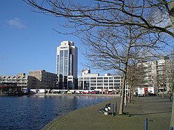
 Buildings in Zoetermeer | |
 Location in South Holland | |
| Coordinates: 52°4′N 4°30′E / 52.067°N 4.500°E | |
| Country | Netherlands |
| Province | South Holland |
| Government | |
| • Body | Municipal council |
| • Mayor | Michel Bezuijen (VVD) |
| Area | |
• Total | 37.05 km2 (14.31 sq mi) |
| • Land | 34.45 km2 (13.30 sq mi) |
| • Water | 2.60 km2 (1.00 sq mi) |
| Elevation | −3 m (−10 ft) |
| Population (January 2021)[4] | |
• Total | 125,267 |
| • Density | 3,636/km2 (9,420/sq mi) |
| Demonym | Zoetermeerder |
| Time zone | UTC+1 (CET) |
| • Summer (DST) | UTC+2 (CEST) |
| Postcode | 2700–2729 |
| Area code | 079 |
| Website | www |
Zoetermeer (Dutch pronunciation: [ˌzutərˈmeːr] ⓘ) is a city in the Western Netherlands, in the province of South Holland. The municipality covers an area of 37.05 km2 (14.31 sq mi) of which 2.60 km2 (1.00 sq mi) is water. A small village until the late 1960s, it had 6,392 inhabitants in 1950.[5] By 2023 this had grown to 126.998, making it the fourth largest population centre in the province of South Holland, after Rotterdam, The Hague and Leiden.[6] While now a city in its own right, Zoetermeer started out as a suburb of The Hague and is still a part of the Greater The Hague urban area.
The name Zoetermeer (Dutch for "freshwater lake") refers to the former lake north of the town (reclaimed in 1614). Because the name literally translates as "sweet lake" local residents have dubbed Zoetermeer "Sweet Lake City".
- ^ "De leden van het college van B&W" [Members of the board of mayor and aldermen] (in Dutch). Gemeente Zoetermeer. Archived from the original on 24 August 2013. Retrieved 30 August 2013.
- ^ "Kerncijfers wijken en buurten 2020" [Key figures for neighbourhoods 2020]. StatLine (in Dutch). CBS. 24 July 2020. Retrieved 19 September 2020.
- ^ "Postcodetool for 2711EC". Actueel Hoogtebestand Nederland (in Dutch). Het Waterschapshuis. Retrieved 30 August 2013.
- ^ "Bevolkingsontwikkeling; regio per maand" [Population growth; regions per month]. CBS Statline (in Dutch). CBS. 1 January 2021. Retrieved 2 January 2022.
- ^ "Nederland per gemeente 1950" Archived March 5, 2007, at the Wayback Machine, NIDI (Netherlands Interdisciplinary Demographic Institute)
- ^ "Top Ten Municipalities in South-Holland". AlleCijfers.nl. Retrieved 13 September 2023.


