Back Dálnice A4 (Německo) Czech Bundesautobahn 4 Danish Bundesautobahn 4 German Bundesautobahn 4 English Germana aŭtovojo A4 Esperanto Bundesautobahn 4 Finnish Bundesautobahn 4 French Zwjazkowa awtodróha 4 HSB A4-es autópálya (Németország) Hungarian Bundesautobahn 4 Italian
| Bundesautobahn 4 | ||
|---|---|---|
|
Renania del Norte-Westfalia, Hesse, Turingia y Sajonia, | ||
 | ||
 | ||
| Datos de la ruta | ||
| Identificador |
| |
| ID europeo |
| |
| Tipo | Autopista | |
| Longitud | 585 | |
| Orientación | ||
| • Este | Aquisgran, frontera con Países Bajos | |
| • Oeste | Görlitz, frontera con Polonia | |
| Cruces | Heerlen Autoweg, Luxemburger Straße, Hermsdorfer Kreuz, Anschlussstelle Limbach-Oberfrohna (de), Autobahnkreuz Chemnitz, Anschlussstelle Chemnitz-Mitte (de), Anschlussstelle Chemnitz-Glösa (de), Autobahndreieck Nossen, Autobahndreieck Dresden-West, Washingtonstraße, Radeburger Straße, Wilschdorfer Landstraße, Hermann-Reichelt-Straße, Autobahndreieck Dresden-Nord y Jędrzychowice-Ludwigsdorf border crossing | |
| Lugares | ||
| Lugares que atraviesa |
tramo occidental Colonia Krombach tramo oriental Kirchheim Herleshausen antigua Frontera_interalemana Erfurt Weimar Jena Chemnitz antigua Ciudad Karl-Marx Dresde Görlitz] el río Neisse | |
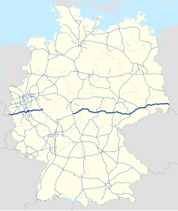
La Bundesautobahn 4 (Abreviatura: BAB 4) – Abreviado: Autobahn 4 (Abreviado: A 4) – se divide en dos tramos, uno occidental y otro oriental. Se construyó entre 1934 y 1937.