.mw-parser-output .reflist{margin-bottom:0.5em;list-style-type:decimal}@media screen{.mw-parser-output .reflist{font-size:90%}}.mw-parser-output .reflist .references{font-size:100%;margin-bottom:0;list-style-type:inherit}.mw-parser-output .reflist-columns-2{column-width:30em}.mw-parser-output .reflist-columns-3{column-width:25em}.mw-parser-output .reflist-columns{margin-top:0.3em}.mw-parser-output .reflist-columns ol{margin-top:0}.mw-parser-output .reflist-columns li{page-break-inside:avoid;break-inside:avoid-column}.mw-parser-output .reflist-upper-alpha{list-style-type:upper-alpha}.mw-parser-output .reflist-upper-roman{list-style-type:upper-roman}.mw-parser-output .reflist-lower-alpha{list-style-type:lower-alpha}.mw-parser-output .reflist-lower-greek{list-style-type:lower-greek}.mw-parser-output .reflist-lower-roman{list-style-type:lower-roman}
| Golle imaaɗe | 1820 |
|---|---|
| Lesdi | Namibiya |
| Nder laamoore | Mukwe Constituency |
| Hiiri-weeti pelle | UTC+01:00 |
| Jonde kwa'odineto | 18°7′0″S 21°37′0″E |

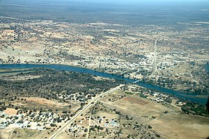
Bagani (1.093 m above sea level) is a settlement on the south-western banks of the Okavango River in the Kavango East Region of Namibia, 200 kilometers (120 mi) east of Rundu and near the Popa Falls on the Okavango River.[1 ] Bagani has a population of around 2,000 inhabitants.
Ha dow fuɗɗam ngal fuɗɗam fuɗɗam haa fuɗnaange fuɗnaare fuɗnaade maayo ɗon ɗon Bufalo nder Caprivi Strip. Yimɓe ɗiɗo ɗon hawta bee laawol laamorde haŋki.

