Back Boesmanland (bantoestan) Afrikaans Бушменленд Bulgarian Bushmanland Catalan Buschmannland German Bushmanland (South West Africa) English Bushmanlandia Spanish Bushmanland French Buszmanland Polish Бушменленд Russian Бушменленд Ukrainian
Bushmanland | |
|---|---|
| 1976–1989 | |
| Template:Infobox country/imagetable | |
|
Location of Bushmanland (green) within South West Africa (grey). | |
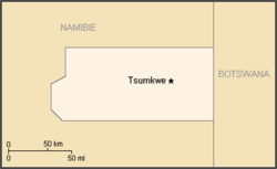
 Map of the bantustan. | |
| Status | Template:Infobox country/status text |
| Capital | Template:Nowrap |
| Common languages |
Khoisan English Afrikaans German |
| History | |
| Template:Infobox country/multirow | |
| Currency | South African rand |
| ISO 3166 code | [[ISO 3166-2:Template:ISO 3166 code|Template:ISO 3166 code]] |
| Template:Infobox country/formernext | |

Bushmanland (Afrik: Boesmanland) laati bantustan haa fombina Hirnaange Afirka (Namibiya hannde), laamu Apartaayd yidi laataago lesdi laamooɗum ngam lenyol San (Bushmen).