Back Абаианг CE Abaiang CEB Abaiang German Αμπαϊάνγκ Greek Abaiang English Abaiang Spanish Abaiang Estonian آبایانگ Persian Abaiang Finnish Atol Abaiang Galician
| Abaiang Apaiang (mul) | ||
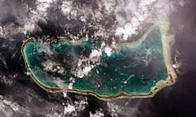
 Image satellite d'Abaiang. | ||
| Géographie | ||
|---|---|---|
| Pays | ||
| Archipel | Îles Gilbert | |
| Localisation | Océan Pacifique | |
| Coordonnées | 1° 50′ 21″ N, 172° 57′ 00″ E | |
| Superficie | 16,4 km2 | |
| Nombre d'îles | 15 | |
| Île(s) principale(s) | Teiro | |
| Géologie | Atoll | |
| Administration | ||
| Aucun découpage territorial | - | |
| Démographie | ||
| Population | 5 568 hab. (2015) | |
| Densité | 339,51 hab./km2 | |
| Plus grande ville | Tuarabu, Nuotaea | |
| Autres informations | ||
| Fuseau horaire | UTC+12 | |
| Géolocalisation sur la carte : Kiribati
| ||
| Îles aux Kiribati | ||
| modifier |
||
Abaiang (parfois écrit Apaiang, même prononciation[1]) est un atoll de la république des Kiribati.
Son nom signifie en gilbertin « terre du nord » (aba « terre », iang « nord ») ou « terre du vent » (te ang, « le vent »). Avant de retrouver son nom autochtone, elle fut baptisée, au début du XIXe siècle, Charlotte Island du nom du bateau (transport de bagnards) du capitaine Thomas Gilbert qui la vit pour la première fois en 1788 qui l'avait baptisée Matthew's Island, du nom du propriétaire de la Charlotte.
