Back Lonq-Aylend boğazı Azerbaijani Лонг-Айленд (праліў) Byelorussian Лонгайлъндски проток Bulgarian Long Island Sound Breton Long Island Sound Catalan Long Island Sound (luuk) CEB Long Island Sound Czech Long Island Sound Danish Long Island Sound German Long Island Sound English
| Long Island Sound | ||||
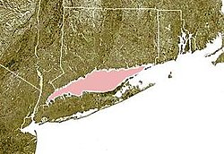
 Carte du Long Island Sound (en rose) entre les côtes du Connecticut (au nord) et de Long Island (au sud). | ||||
| Géographie humaine | ||||
|---|---|---|---|---|
| Pays côtiers | ||||
| Subdivisions territoriales |
État de New York, Connecticut | |||
| Géographie physique | ||||
| Type | Détroit | |||
| Localisation | Océan Atlantique | |||
| Coordonnées | 41° 05′ 48″ nord, 72° 53′ 30″ ouest | |||
| Subdivisions | Manhasset Bay, Oyster Bay, Huntington Bay, Northport Bay, Smithtown Bay, Niantic Bay, Captain Harbor | |||
| Longueur | 156 km | |||
| Largeur | ||||
| · Maximale | 32 km | |||
| · Minimale | 3 km | |||
| Géolocalisation sur la carte : États-Unis
Géolocalisation sur la carte : État de New York
Géolocalisation sur la carte : Connecticut
| ||||
| modifier |
||||
Le Long Island Sound, en français : « détroit de Long Island », est un détroit des États-Unis située entre les côtes du Connecticut au nord et celles de Long Island au sud dépendant de l'État de New York.


