Back سيدي راشد Arabic سيدى راشد ARZ سیدی راشد AZB Sidi Rached English Sidi Rached Spanish سیدی راشد Persian Sidi Rached Italian Sidi Raced KAB Sidi Rached Malay Sidi Rached Portuguese
| Sidi Rached | ||||
 Entrée de la ville de Sidi Rached | ||||
| Noms | ||||
|---|---|---|---|---|
| Nom arabe | سيدي راشد | |||
| Nom amazigh | ⵙⵉⴷⵉ ⵔⴰⵛⴻⴷ | |||
| Administration | ||||
| Pays | ||||
| Wilaya | Tipaza | |||
| Daïra | Ahmar El Aïn | |||
| Code postal | 42250 | |||
| Code ONS | 4234 | |||
| Démographie | ||||
| Population | 11 062 hab. (2008[1]) | |||
| Densité | 197 hab./km2 | |||
| Géographie | ||||
| Coordonnées | 36° 33′ 45″ nord, 2° 32′ 00″ est | |||
| Altitude | Min. 60 m Max. 280 m |
|||
| Superficie | 56,17 km2 | |||
| Localisation | ||||
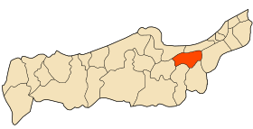
 Localisation de la commune dans la wilaya de Tipaza. | ||||
| Géolocalisation sur la carte : Algérie
Géolocalisation sur la carte : Algérie
Géolocalisation sur la carte : Algérie (nord)
| ||||
| modifier |
||||
Sidi Rached (anciennement Montebello pendant la colonisation française), est une commune de la wilaya de Tipaza en Algérie.


