Back Le Hamel (Somme) AST Le Hamel, Somme BUG Le Hamel (Somme) Catalan Ле-Амель (Сомма) CE Le Hamel, Somme CEB Le Hamel (Somme) German Le Hamel, Somme English Le Hamel (Somme) Spanish Le Hamel (Somme) Basque Le Hamel (Somme) French
Le Hamel | |
|---|---|
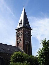
 Gereja di Le Hamel | |
| Koordinat: 49°53′00″N 2°34′00″E / 49.8833°N 2.5667°E | |
| Negara | Prancis |
| Region | Hauts-de-France |
| Departemen | Somme |
| Arondisemen | Amiens |
| Kanton | Corbie |
| Antarkomune | Val de Somme |
| Pemerintahan | |
| • Wali kota (2020–2026) | Stéphane Chevin[1] |
| Luas | |
| • Land1 | 9,12 km2 (352 sq mi) |
| • Populasi2 | 488 |
| • Kepadatan Populasi2 | 0,54/km2 (1,4/sq mi) |
| Kode INSEE/pos | 80411 / 80800 |
| Ketinggian | 28–101 m (92–331 ft) (rerata 83 m or 272 ft) |
| 1 Data Pendaftaran Tanah Prancis, tak termasuk danau, kolam, gletser > 1 km² (0.386 mi² atau 247 ekar) dan muara sungai. 2 Population sans doubles comptes: penghitungan tunggal penduduk di komune lain (e.g. mahasiswa dan personil militer). | |
Le Hamel adalah sebuah commune di departmen Somme berada pada region Hauts-de-France bagian utara Prancis.
- ^ "Répertoire national des élus: les maires". data.gouv.fr, Plateforme ouverte des données publiques françaises (dalam bahasa Prancis). 2 December 2020.


