Back Лесото Abkhazian Lesotho ACE Lesotho Afrikaans Lesotho ALS ሌሶቶ Amharic Lesotho AMI Lesoto AN Lesotho ANG Lesoto ANN लेसोथो ANP
| 'Muso oa Lesotho Kingdom of Lesotho | ||||
|---|---|---|---|---|

| ||||
| Basisgegevens | ||||
| Officiële taal | Zuid-Sotho, Engels | |||
| Hoofdstad | Maseru | |||
| Regeringsvorm | Constitutionele monarchie | |||
| Staatshoofd | Koning Letsie III | |||
| Regeringsleider | Sam Matekane | |||
| Religie | Christendom 90%[1] | |||
| Oppervlakte | 30.355 km²[2] (-% water) | |||
| Inwoners | 1.880.661 (2006)[3] 1.969.334 (2020)[4] (64,9/km² (2020)) | |||
| Bijv. naamwoord | Lesothaans | |||
| Inwoneraanduiding | Lesothaan (m./v.) Lesothaanse (v.) | |||
| Overige | ||||
| Motto | Khotso, Pula, Nala | |||
| Volkslied | Lesotho Fatse La Bontata Rona | |||
| Munteenheid | Loti, rand (LSR, ZAR)
| |||
| UTC | +2 | |||
| Nationale feestdag | 4 oktober | |||
| Web | Code | Tel. | .ls | LSO | 266 | |||
| Voorgaande staten | ||||
| ||||
| Detailkaart | ||||

| ||||
|
Portaal
| ||||
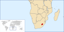
Lesotho (uitspraak: [ləˈsoto]) is een land in Afrika dat geheel wordt omsloten door Zuid-Afrika. Op 4 oktober 1966 verwierf de toenmalige Britse kroonkolonie Basutoland onafhankelijkheid en kreeg het de naam Koninkrijk Lesotho (Zuid-Sotho: Muso oa Lesotho, Engels: Kingdom of Lesotho). Een gekozen regering werd in ere hersteld in 1993. De hoofdstad van Lesotho is Maseru. Het land is lid van het Gemenebest van Naties.
- ↑ (en) International Religious Freedom Report 2007, US Department of State, 14 september 2007
- ↑ (en) Verenigde Naties 2013
- ↑ a b (en) Laatste census 9 april 2006 (via V.N.)
- ↑ Niet-officiële schatting CIA Factbook juli 2020, berekend door US Bureau of the Census (gearchiveerd)

