Back مقاطعة بلاسر (كاليفورنيا) Arabic Pleser qraflığı (Kaliforniya) Azerbaijani Placer County, Kalifornien BAR Плейсър Bulgarian প্লাসের কাউন্টি, ক্যালিফোর্নিয়া BPY Плейсер (гуо, Калифорни) CE Placer County CEB Placer County Czech Placer County, Califfornia Welsh Placer County Danish
| County in de Verenigde Staten | |||
|---|---|---|---|

| |||
| Situering | |||
| Staat | Californië | ||
| Coördinaten | 39°3'36"NB, 120°43'48"WL | ||
| Algemeen | |||
| Oppervlakte | 3.892 km² | ||
| - land | 3.637 km² | ||
| - water | 255 km² | ||
| Inwoners (2000) |
248.399 (68 inw./km²) | ||
| Overig | |||
| Zetel | Auburn | ||
| FIPS-code | 06061 | ||
| Opgericht | 1851 | ||
| Foto's | |||
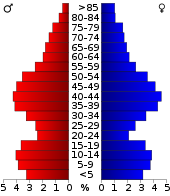
 Bevolkingspiramide Placer County | |||
| Statistieken volkstelling Placer County | |||
| |||

Placer County is een county in Californië in de VS. Het werd gevormd in 1851 en bestond uit delen van Sutter en Yuba county's.
"Placer" is waarschijnlijk een samentrekking van "plaza de oro" wat betekent 'de plaats van goud'. De county kreeg deze naam door de vele plaatsen waar goud, door middel van extractie uit de aarde, ontgonnen werd. In het Engels wordt dit "placer mining" genoemd.