Back Municipio Atabapo AN Municipio Autónomo Atabapo CEB Atabapo Municipality English Municipio Atabapo Spanish Atabapo French Atabapo Italian ატაბაპოს მუნიციპალიტეტი Georgian Atabapo Dutch Atabapo Portuguese Atabapo (khu tự quản) Vietnamese
Autònomo Atabapo Municipality Municipio Autònomo Atabapo | |
|---|---|
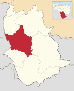
 Location in Amazonas | |
| Coordinates: 3°43′33″N 66°49′58″W / 3.7258°N 66.8328°WCoordinates: 3°43′33″N 66°49′58″W / 3.7258°N 66.8328°W | |
| Kintra | |
| State | Amazonas |
| Municipal seat | San Fernando de Atabapo |
| Govrenment | |
| • Mayor | Nelsón Cayupare (PPT) |
| Area | |
| • Total | 25142.5 km2 (9,707.6 sq mi) |
| Population (2011) | |
| • Total | 9,169 |
| • Density | 0.36/km2 (0.94/sq mi) |
| Time zone | UTC−04:00 (VET) |
| Aurie code(s) | 0248 |
Warning: Page uisin Template:Infobox Venezuelan municipality wi unkent parameter "image_map" (this message is shown only in preview).
Warning: Page uisin Template:Infobox Venezuelan municipality wi unkent parameter "country" (this message is shown only in preview).
Warning: Page uisin Template:Infobox Venezuelan municipality wi unkent parameter "website" (this message is shown only in preview).
Warning: Page uisin Template:Infobox Venezuelan municipality wi unkent parameter "population_density" (this message is shown only in preview).
Warning: Page uisin Template:Infobox Venezuelan municipality wi unkent parameter "website_name" (this message is shown only in preview).
Warning: Page uisin Template:Infobox Venezuelan municipality wi unkent parameter "time_zone" (this message is shown only in preview).
Warning: Page uisin Template:Infobox Venezuelan municipality wi unkent parameter "area" (this message is shown only in preview).
The Atabapo Municipality is ane o the seiven municipalities (municipios) that mak up the soothren Venezuelan state o Amazonas an, accordin tae the 2011 census bi the Naitional Institute o Statistics o Venezuela, the municipality haes a population o 9,169.[1] The toun o San Fernando de Atabapo is the shire toun o the Atabapo Municipality.[2]

