Back Bihar ACE Bihar Afrikaans Bihar ALS ብሓር Amharic Bihar ANG बिहार ANP بهار (الهند) Arabic বিহাৰ Assamese Bihar AST बिहार AWA
Bihar बिहार | |
|---|---|
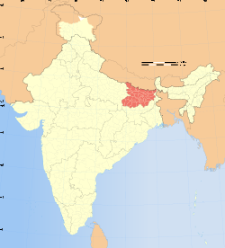
 Location o Bihar in Indie | |
| Coordinates (Patna): 25°22′N 85°08′E / 25.37°N 85.13°E | |
| Kintra | Indie |
| Region | Angika Region, Bhojpur Region, Magadh Region, Mithila Region |
| Diveesion | Patna, Tirhut, Saran, Darbhanga, Kosi, Purnia, Bhagalpur, Munger, Magadha |
| Established | 1912 (as Bihar) |
| Caipital | Patna |
| Lairgest ceety | Patna |
| Destricts | 38 total |
| Govrenment | |
| • Bodi | Govrenment o Indie, Govrenment o Bihar |
| • Govrenor | Devanand Konwar |
| • Chief Meenister | Nitish Kumar (JDU) |
| • Legislatur | Bicameral (243 + 75 seats) |
| • Parliamentary constituency | 40 |
| • Heich Court | Patna Heich Court |
| Area | |
| • Total | 94,163 km2 (36,357 sq mi) |
| Area rank | 12t |
| Population (2011)[1] | |
| • Total | 103,804,637 |
| • Rank | 3rd |
| • Density | 1,100/km2 (2,900/sq mi) |
| Time zone | UTC+05:30 (IST) |
| UN/LOCODE | INBR |
| ISO 3166 code | IN-BR |
| Vehicle registration | BR |
| Human Development Index | |
| HDI rank | 21st (2011) |
| Literacy | 63.82% (28t) 73.4% (male) 53.3% (female) |
| Offeecial leid(s) | Hindi, Urdu, Maithili,[2] |
| Website | gov.bih.nic.in |
Warning: Page uisin Template:Infobox settlement wi unkent parameter "sex_ratio" (this message is shown only in preview).
Bihar (/bᵻˈhɑːr/, pronounced [bɪˈɦaːr] (![]() listen)) is a state in northren Indie.[3][4] It is the 12t lairgest state in terms o geografical size at 38,202 sq mi (98,940 km2) an 3rd lairgest bi population. Amaist 58% o Biharis is ablo the age o 25,[5] whilk is the heichest proportion in Indie.
listen)) is a state in northren Indie.[3][4] It is the 12t lairgest state in terms o geografical size at 38,202 sq mi (98,940 km2) an 3rd lairgest bi population. Amaist 58% o Biharis is ablo the age o 25,[5] whilk is the heichest proportion in Indie.
The Bihar plain is dividit intae twa pairts bi the river Ganges whilk rins through the middle frae wast tae east.[6] Bihar haes notifee'd forest aurie o 6,764.14 km2,[7] whilk is 6.8% o its geografical aurie. Hindi an Urdu is the offeecial leids o the state, while the majority o the fowk speak Angika, Bhojpuri, Magadhi, Maithili and Bajjika. In 2000, Bihar wis divided intae 2 pairts, the Southren part kent as Jharkhand.
- ↑ "census of india". Census of India 2001. Government of India. 27 Mey 2002. Retrieved 14 Apryle 2007.
- ↑ "National Commissioner Linguistic Minorities". Archived frae the original on 10 Apryle 2009. Retrieved 10 December 2010.
- ↑ "State Profile". Bihar Government website. Archived frae the original on 8 Februar 2010. Retrieved 23 Januar 2021.
- ↑ "Food riots, anger as floods swamp South Asia". Reuters India. 22 August 2008. Archived frae the original on 7 September 2008. Retrieved 25 October 2012.
- ↑ Guruswamy, Mohan; Abhishek, Kaul (15 December 2003). "The Economic Strangulation of Bihar" (PDF). Centre for Policy Alternatives, New Delhi, India. Archived frae the original (PDF) on 30 Mey 2009. Retrieved 25 October 2012.
- ↑ "State Profile". Archived frae the original on 22 September 2017. Retrieved 25 October 2012.
- ↑ "State Profile". Gov. of India.
