Back Mongolia Dalam ACE Binne-Mongolië Afrikaans منغوليا الداخلية Arabic Mongolia Interior AST Daxili Monqolustan Muxtar Rayonu Azerbaijani داخیلی موغولیستان AZB Mongolia Jero BAN Innare Mongolei BAR Унутраная Манголія Byelorussian Унутраная Манголія BE-X-OLD
Inner Mongolie Autonomous Region Nei Mongol Autonomous Region 内蒙古自治区 | |
|---|---|
| Name transcription(s) | |
| • Cheenese | 内蒙古自治区 (Nèi Měnggǔ Zìzhìqū) |
| • Abbreviation | 内蒙 or 内蒙古[1] (pinyin: Nèi Měng or Nèi Měnggǔ) |
| Mongolie transcription(s) | |
•  , , | Öbür mongγol-un öbertegen zasaqu orun[2] |
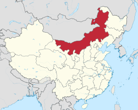
 Map shawin the location o Inner Mongolie Autonomous Region Nei Mongol Autonomous Region | |
| Named for | Frae the Mongolie öbür monggol, whaur öbür means the front, sunny side o natural barrier (a muntain, muntain range, lake or desert etc..). |
| Caipital | Hohhot |
| Lairgest ceety | Baotou |
| Divisions | 12 prefecturs, 101 coonties, 1425 tounships |
| Govrenment | |
| • Secretar | Hu Chunhua |
| • Govrenor | Bagatur |
| Area | |
| • Total | 1183000 km2 (457,000 sq mi) |
| Area rank | 3rd |
| Population (2010) | |
| • Total | 24,706,321[3] |
| • Rank | 23rd |
| • Density rank | 28t |
| Demographics | |
| • Ethnic composeetion | Han - 79% Mongols - 17% Manchu - 2% Hui - 0.9% Daur - 0.3% |
| ISO 3166 code | CN-15 |
| GDP (2011) | CNY 1.40 trillion US$ 218.75 billion (15t) |
| • per capita | CNY 56,666 US$ 8,854 (6t) |
| HDI (2008) | 0.803 (high) (13t) |
| Website | http://www.nmg.gov.cn (Simplifeed Cheenese) |
Inner Mongolie (Mongolie: s ![]() , Öbür Monggol an c Өвөр Монгол, Övör Mongol; Cheenese: 内蒙古; pinyin: Nèi Měnggǔ, but offeecially romanizit tae Nei Mongol) is an autonomous region o the Fowkrepublic o Cheenae, located in the northren region o the kintra. Inner Mongolie shares an internaitional border wi the kintras o Mongolie an the Roushie Federation. Its caipital is Hohhot an the lairgest ceety is Baotou.
, Öbür Monggol an c Өвөр Монгол, Övör Mongol; Cheenese: 内蒙古; pinyin: Nèi Měnggǔ, but offeecially romanizit tae Nei Mongol) is an autonomous region o the Fowkrepublic o Cheenae, located in the northren region o the kintra. Inner Mongolie shares an internaitional border wi the kintras o Mongolie an the Roushie Federation. Its caipital is Hohhot an the lairgest ceety is Baotou.
Inner Mongolie Autonomous Region wis established in 1947 on the aurie o umwhile Republic o Cheenae provinces o Suiyuan, Chahar, Rehe, Liaopeh an Hsingan. It is the third-lairgest subdiveesion o Cheenae spannin aboot 1,200,000 km² (463,000 sq mi) or 12% o Cheenae's total land aurie. It haes a population o aboot 24 million as o 2004. The majority o the population in the region are Han Cheenese, wi a substantial Mongol minority. The offeecial leids are Cheenese an Mongolie, the latter written in the Mongolie script, as opposed tae the Mongolie Cyrillic alphabet uised in the state o Mongolie.
- ↑ 内蒙古自治区区情
- ↑ The Cyrillic spellin, as uised in Mongolie, wad be Өвөр Монголын Өөртөө Засах Орон (Övör Mongolyn Öörtöö Zasakh Oron).
- ↑ "Communiqué of the National Bureau of Statistics of People's Republic of China on Major Figures of the 2010 Population Census". National Bureau of Statistics of China. Archived frae the original on 27 Julie 2013. Retrieved 9 Mairch 2012.