Back Prefektur Osaka ACE Osaka-prefektuur Afrikaans Ōsacascir ANG أوساكا (محافظة) Arabic محافظة اوساكا ARZ Prefeutura d'Osaka AST Osaka prefekturası Azerbaijani اوساکا اوستانی AZB Préféktur Osaka BAN Osakas prefektūra BAT-SMG
Osaka Prefecture 大阪府 | |
|---|---|
| Japanese transcription(s) | |
| • Japanese | 大阪府 |
| • Rōmaji | Ōsaka-fu |
 | |
| Coordinates: 34°41′11″N 135°31′12″E / 34.68639°N 135.52000°ECoordinates: 34°41′11″N 135°31′12″E / 34.68639°N 135.52000°E | |
| Kintra | Japan |
| Region | Kansai |
| Island | Honshu |
| Caipital | Osaka |
| Govrenment | |
| • Govrenor | Ichiro Matsui |
| Area | |
| • Total | 1899.28 km2 (733.32 sq mi) |
| Area rank | 46t |
| Population (1 Januar 2012) | |
| • Total | 8,864,228 |
| • Rank | 3rd |
| • Density | 4,700/km2 (12,000/sq mi) |
| ISO 3166 code | JP-27 |
| Destricts | 5 |
| Municipalities | 43 |
| Flouer | Japanese apricot (Prunus mume) Primrose (Primula sieboldii) |
| Tree | Ginkgo tree (Ginkgo biloba) |
| Bird | Bull-headed shrike (Lanius bucephalus) |
| Website | www |
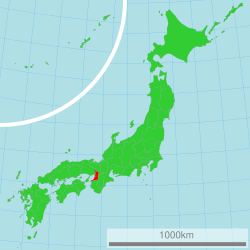
Osaka Prefectur (大阪府 Ōsaka-fu) is a prefectur locatit in the Kansai region on Honshu, the main island o Japan.[1] The caipital is the ceety o Osaka. It is the centre o Osaka-Kobe-Kyoto aurie.[2]
- ↑ Nussbaum, Louis-Frédéric. (2005). "Osaka-fu" in Japan Encyclopedia, p. 759 at Google Books; "Kansai" in p. 477 at Google Books.
- ↑ Nussbaum, "Osaka" in p. 759 at Google Books.
