Back Sahara Afrikaans Sahara ALS ሰሐራ በረሓ Amharic Desierto d'o Sahara AN Èwê Sayara ANN सहारा ANP الصحراء الكبرى Arabic ܨܚܪܐܐ ARC الصحرا لكبيرة ARY الصحرا الكبرى ARZ
| Sahara (الصحراء الكبرى) | |
| The Great Desert | |
| Desert | |
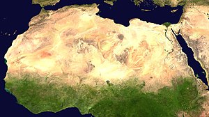
A satellite image o the Sahara bi NASA Warld Wind.
| |
| Kintras | Algerie, Chad, Egyp, Eritrea, Libie, Mali, Mauritanie, Morocco, Niger, Sudan, Tunisie, Wastren Sahara |
|---|---|
| Heichest pynt | Emi Koussi 11,204 ft (3,415 m) |
| - coordinates | 19°47′36″N 18°33′6″E / 19.79333°N 18.55167°E |
| Lowest point | Qattara Depression −436 ft (−133 m) |
| - coordinates | 30°0′0″N 27°5′0″E / 30.00000°N 27.08333°E |
| Lenth | 4,800 km (2,983 mi), E/W |
| Width | 1,800 km (1,118 mi), N/S |
| Area | 9,400,000 km2 (3,629,360 sq mi) |
| Biome | Desert |
The Sahara (Arabic: الصحراء الكبرى, aṣ-Ṣaḥrāʾ al-Kubrā , 'the Greatest Desert') is the warld's hettest desert, the third mucklest desert efter Antarcticae an the Arctic.[1] At ower 9,400,000 square kilometre (3,600,000 sq mi), it covers maist o North Africae, makkin it naur sae muckle as Cheenae or the Unitit States. The Sahara stents frae the Reid Sea, includin pairts o the Mediterranean coasts, tae the ootskirts o the Atlantic Ocean. Soothlins, it is deleemitit bi the Sahel, a belt o semi-arid tropical savanna that composes the northren region o central an wastren Sub-Saharan Africae.
Some o the saund dunes can reach 180 metre (590 ft) in heicht.[2] The name comes frae the plural Arabic leid wird for desert, (صحارى ṣaḥārā [3][4] [ˈsˤɑħɑ:rɑ:];[5][6]
- ↑ "Largest Desert in the World". Retrieved 30 December 2011.
- ↑ Arthur N. Strahler and Alan H. Strahler. (1987) Modern Physical Geography Third Edition. New York: John Wiley & Sons. Page 347
- ↑ "Sahara." Online Etymology Dictionary. Douglas Harper, Historian. Retrieved June 25, 2007.
- ↑ "English-Arabic online dictionary". Online.ectaco.co.uk. 28 December 2006. Archived frae the original on 9 Mairch 2009. Retrieved 12 Juin 2010.
- ↑ Wehr, Hans (1994). A Dictionary of Modern Written Arabic (Arabic-English) (4th ed.). Wiesbaden: Otto Harrassowitz. p. 589. ISBN 0-87950-003-4.
- ↑ al-Ba‘labakkī, Rūḥī (2002). al-Mawrid: Qāmūs ‘Arabī-Inklīzī (in Arabic) (16th ed.). Beirut: Dār al-‘Ilm lil-Malāyīn. p. 689.
