Back Самоа Abkhazian Samoa ACE Samoa Afrikaans Samoa ALS ሳሞዓ Amharic Samoa AMI Samoa AN Samoa ANG सामोआ ANP ساموا Arabic
Coordinates: 13°35′S 172°20′W / 13.583°S 172.333°W
Independent State o Samoa Malo Saʻoloto Tutoʻatasi o Sāmoa (Samoan) | |
|---|---|
 | |
| Caipital and largest city | Apia 13°50′S 171°45′W / 13.833°S 171.750°W |
| Offeecial leids | |
| Ethnic groups (2001) |
|
| Releegion | Christianity (offeecial)[2] |
| Demonym(s) | Samoan |
| Govrenment | Unitary pairlamentar democracy |
| Tuimalealiifano Va'aletoa Sualauvi II | |
| Fiame Naomi Mataʻafa | |
| Legislatur | Legislative Assembly |
| Unthirldom frae New Zealand | |
| 14 Juin 1889 | |
| 16 Februar 1900 | |
| 1 Mairch 1900 | |
| 30 August 1914 | |
• League mandate | 17 December 1920 |
• UN trusteeship | 13 December 1946 |
• Wastren Samoa Act 1961 | 1 Januar 1962 |
| Aurie | |
• Total | 2,842 km2 (1,097 sq mi) (167th) |
• Water (%) | 0.3 |
| Population | |
• November 2016 census | 192,342[3] |
• Density | 68/km2 (176.1/sq mi) |
| GDP (PPP) | 2016 estimate |
• Total | $1.046 billion[4] |
• Per capita | $5,368[4] |
| GDP (nominal) | 2016 estimate |
• Tot | $876 million[4] |
• Per capita | $4,496[4] |
| HDI (2014) | heich · 105t |
| Currency | Tala (WST) |
| Time zone | UTC+13b (UTC+13:00) |
• Summer (DST) | UTC+14 (UTC+14:00) |
| Drivin side | leftc |
| Cawin code | +685 |
| ISO 3166 code | WS |
| Internet TLD | .ws |
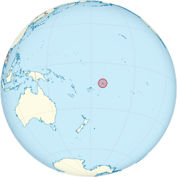
Samoa /səˈmoʊə/ (![]() listen), offeecially the Independent State o Samoa, umwhile kent as Wastren Samoa an German Samoa, is a kintra governin the wastren pairt o the Samoan Islands in the Sooth Paceefic Ocean. It became independent frae New Zealand in 1962. The twa main islands o Samoa are Upolu an ane o the biggest islands in Polynesie, Savai'i. The caipital ceety, Apia, an Faleolo Internaitional Airport are situatit on the island o Upolu.
listen), offeecially the Independent State o Samoa, umwhile kent as Wastren Samoa an German Samoa, is a kintra governin the wastren pairt o the Samoan Islands in the Sooth Paceefic Ocean. It became independent frae New Zealand in 1962. The twa main islands o Samoa are Upolu an ane o the biggest islands in Polynesie, Savai'i. The caipital ceety, Apia, an Faleolo Internaitional Airport are situatit on the island o Upolu.
- ↑ "Samoa". CIA – The World Factbook. Archived frae the original on 21 Mey 2016. Retrieved 10 Februar 2018.
- ↑ Wyeth, Grant (16 Juin 2017). "Samoa Officially Becomes a Christian State". The Diplomat. Archived frae the original on 16 Juin 2017. Retrieved 16 Juin 2017. Italic or bold markup not allowed in:
|publisher=(help) - ↑ "Census 2016 Preliminary Count". Samoa Bureau of Statistics. p. 3. Archived frae the original on 17 September 2017. Retrieved 2 Februar 2017.
- ↑ a b c d "Samoa". International Monetary Fund.
- ↑ "2015 Human Development Report Statistical Annex" (PDF). United Nations Development Programme. 2015. p. 13. Retrieved 14 December 2015.
- ↑ Staff/Agencies (31 December 2011). "Samoa skips Friday in time zone change". ABC Australia. Archived frae the original on 16 Januar 2012. Retrieved 16 Januar 2012. Unknown parameter
|deadurl=ignored (help) - ↑ Chang, Richard S. (8 September 2009). "In Samoa, Drivers Switch to Left Side of the Road". The New York Times. Retrieved 23 Mey 2010.

