Back Municipio Sucre (munisipyo sa Miranda) CEB Sucre Municipality, Miranda English Municipio Sucre (Miranda) Spanish Sucre (Miranda) French Sucre (Miranda) Italian スクレ市 (ミランダ州) Japanese სუკრეს მუნიციპალიტეტი (მირანდა) Georgian 수크레시 (미란다주) Korean Sucre (Miranda) Dutch Sucre (Miranda) Portuguese
Municipio Sucre (Sucre Municipality) | |
|---|---|
 Dulce Nombre de Jesús de Petare Kirk | |
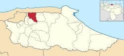
 Sucre in Miranda State | |
| Coordinates: 10°29′N 66°49′W / 10.483°N 66.817°WCoordinates: 10°29′N 66°49′W / 10.483°N 66.817°W | |
| Kintra | |
| State | Miranda |
| Seat | Petare |
| Foondit | 17 Februar 1621 |
| Incorporated | 1989 |
| Govrenment | |
| • Mayor | Carlos Ocariz (Primero Justicia) |
| Area | |
| • Total | 164 km2 (63 sq mi) |
| Population (2012) | |
| • Total | 665,203 |
| • Density | 3907.09/km2 (1508.53/sq mi) |
| Time zone | UTC-4:30 (VST) |
| • Summer (DST) | UTC-4:30 (not observed) |
| Area code(s) | 0212 |
| Website | www.alcaldiamunicipiosucre.gov.ve |
Sucre Municipality is one of the 21 municipalities (municipios) that mak up the Venezuelan state o Miranda an ane o the municipalities that mak up the Metropolitan Destrict o Caracas. Accordin tae a 2007 population estimate bi the Naitional Institute o Statistics o Venezuela, the municipality haes a population o 640,762.[1] The ceety o Petare is the shire toun o the Sucre Municipality.[2] The municipality is ane o several in Venezuela namit "Sucre Municipality" in honour o Venezuelan unthirldom hero Antonio José de Sucre.


