Back Тлахиако Bulgarian Heroica Ciudad de Tlaxiaco (kapital sa munisipyo) CEB Tlaxiaco English Heroica Ciudad de Tlaxiaco Spanish Tlaxiaco French ტლასიაკო Georgian Эройка-Сьюдад-де-Тлахьяко Russian Heroica Ciudad de Tlaxiaco, Heroica Ciudad de Tlaxiaco Serbo-Croatian Ероика Сиудад де Тлаксијако (Ероика Сиудад де Тлаксијако, Оахака) Serbian Tlaxiaco Swedish
Heroica Ciudad de Tlaxiaco | |
|---|---|
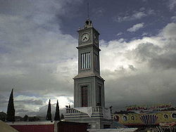
 Monumental clock in Tlaxiaco | |
| Coordinates: 17°16′N 97°41′W / 17.267°N 97.683°W | |
| Kintra | |
| State | Oaxaca |
| Municipality | Tlaxiaco |
| Foondit | ca. 400 BC |
| Toun status | 1 October 1852 |
| Ceety status | 7 October 1884 |
| Area (municipality) | |
| • Total | 343.2 km2 (132.5 sq mi) |
| Elevation | 2040 m (6,690 ft) |
| Population (2005) | |
| • Ceety | 17450 |
| • Municip. | 34587 |
| Time zone | UTC-6 (CST) |
| Postal code | 69800 |
| Area code(s) | 953 |
| Fiestas | 14–21 October |
| Demonym | Tlaxiaqueño |
| Website | http://www.tlaxiaco.gob.mx/ |
Tlaxiaco is a ceety, an its surroondin municipality o the same name, in the Mexican state o Oaxaca. It is locatit in the Tlaxiaco Destrict in the sooth o the Mixteca Region, wi a population o aboot 17,450. The ceety is formally kent as Heroica Ciudad de Tlaxiaco ("heroic ceety") in honour o a battle wagit thare durin the 1862–67 French invasion. Tlaxiaco [t͡ɬa.'ʃia.ko] is a Nahuatl name containin the elements tlachtli [t͡ɬ'at͡ʃt͡ɬi] (ball game), quiahuitl [ki'awit͡ɬ] (rain), an -co [ko] (place marker). It thus approximates tae "Place whaur it rains on the baw court". Its name in the Mixtec leid is Ndijiinu, which means "guid view".[1]
- ↑ Tlaxiaco Archived 2012-03-20 at the Wayback Machine (Enciclopedia de los municipios de México)]

