Back Zagreb Afrikaans Zagreb ALS ዛግሬብ Amharic Zagreb AN Agram ANG زغرب Arabic زاݣريب ARY زاجريب ARZ Zagreb AST Zagreb AVK
Zagreb | ||||||||
|---|---|---|---|---|---|---|---|---|
Ceety | ||||||||
| Ceety o Zagreb Grad Zagreb | ||||||||
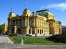
Clockwise, frae tap: Zagreb ceety view; Croatie Naitional Theatre; Cibona an HOTO touers; Arena Zagreb; Trams in Zagreb an Airt Pavilion | ||||||||
 Ceety o Zagreb (licht orange) athin Croatie (licht yellae) | ||||||||
| Coordinates: 45°49′0″N 15°59′0″E / 45.81667°N 15.98333°ECoordinates: 45°49′0″N 15°59′0″E / 45.81667°N 15.98333°E | ||||||||
| Kintra | ||||||||
| Coonty | Ceety o Zagreb | |||||||
| RC diocese | 1094 | |||||||
| Free ryal ceety | 1242 | |||||||
| Unifeed | 1850 | |||||||
| Subdiveesions | 17 destricts 70 settlements | |||||||
| Govrenment | ||||||||
| • Teep | Mayor-Cooncil | |||||||
| • Mayor | Milan Bandić | |||||||
| • Ceety Cooncil | Aicht pairties/leets
| |||||||
| Area | ||||||||
| • Ceety | 641 km2 (247 sq mi) | |||||||
| • Urban | 162.2 km2 (62.6 sq mi) | |||||||
| • Metro | 3719 km2 (1,436 sq mi) | |||||||
| Elevation | 158 m (518 ft) | |||||||
| Highest elevation | 1035 m (3,396 ft) | |||||||
| Lowest elevation | 122 m (400 ft) | |||||||
| Population | ||||||||
| • Ceety | 792,875 | |||||||
| • Estimate (2015)[6] | 799,565 | |||||||
| • Density | 1,200/km2 (3,200/sq mi) | |||||||
| • Urban | 688,163 | |||||||
| • Urban density | 4200/km2 (11,000/sq mi) | |||||||
| • Metro | 1,113,111 | |||||||
| Time zone | UTC+1 (CET) | |||||||
| • Summer (DST) | UTC+2 (CEST) | |||||||
| Postal code | HR-10000 | |||||||
| Aurie code | +385 1 | |||||||
| Vehicle registration | ZG | |||||||
| Website | zagreb.hr | |||||||
Warning: Page uisin Template:Infobox settlement wi unkent parameter "image_photo" (this message is shown only in preview).
Zagreb is the caipital an lairgest ceety in Croatie. It is locatit in the northwast o the kintra, alang the Sava river, at the soothren slopes o the Medvednica muntain. Zagreb lees at an elevation o approximately 122 m (400 ft) abuin sea level.
- ↑ "City of zagreb 2006". City of Zagreb, Statistics Department. Archived frae the original on 11 October 2007. Retrieved 25 Januar 2008. Unknown parameter
|deadurl=ignored (help)"Archived copy". Archived frae the original on 25 December 2018. Retrieved 21 Apryle 2017.CS1 maint: archived copy as title (link) - ↑ "Statistički ljetopis Grada Zagreba 2007" (PDF) (in Croatian and English). 2007. ISSN 1330-3678. Archived frae the original (PDF) on 3 December 2008. Retrieved 12 November 2008. Cite journal requires
|journal=(help)CS1 maint: unrecognised leid (link) - ↑ "Citypopulation".
- ↑ "Population by Age and Sex, by Settlements, 2011 Census: City of Zagreb". Zagreb: Croatian Bureau of Statistics. December 2012. Retrieved 31 August 2014.
- ↑ "Population by age and sex, by districts of City of Zagreb" (HTML). Census of Population, Households and Dwellings 2011. Zagreb: Croatian Bureau of Statistics. December 2012. Retrieved 31 August 2014.
- ↑ "Population estimate of Republic of Croatia, 2015". Croatian Bureau of Statistics (in Inglis and Croatian). 14 September 2016. Archived frae the original on 19 Mairch 2017. Retrieved 27 December 2016.


