Back Arabiese See Afrikaans Arabisches Meer ALS የአረቢያ ባሕር Amharic सिंधु सागर ANP بحر العرب Arabic بحر العرب ARZ আৰৱ সাগৰ Assamese Mar Arábigu AST अरब सागर AWA Ərəbistan dənizi Azerbaijani
| Arabian Sea | |
|---|---|
 | |
 | |
| Coordinates | 14°N 65°E / 14°N 65°E |
| Type | Sea |
| Native name | بَحرُ ٱلْعَرَبْ (Arabic) |
| Part of | Indian Ocean |
| Basin countries | India, Iran, Maldives, Oman, Pakistan, Yemen, Seychelles |
| Max. width | 2,400 km (1,500 mi) |
| Surface area | 3,862,000 km2 (1,491,000 sq mi) (3,600,000 to 4,600,000 km2 in various sources) |
| Max. depth | 4,652 m (15,262 ft) |
| Islands | Astola island, Basavaraja Durga Island, Lakshadweep, Masirah Island, Piram Island, Pirotan, Socotra |


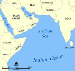
The Arabian Sea is the northwest part of the Indian Ocean. To its west are the Guardafui Channel, Somali Sea and the Arabian Peninsula. To its east is the Indian Peninsula. It covers around 4,600,000 kilometres (2,900,000 miles). The Arabian Sea is one of the warmest seas.