Back Ashfield (bahin nga lungsod) CEB Ashfield, New South Wales English اشفیلد، نیو ساوت ولز Persian Ashfield (Nouvelle-Galles du Sud) French Ashfield (Nuovo Galles del Sud) Italian Ashfield (New South Wales) Dutch Ashfield (Nova Gales do Sul) Portuguese Ashfield, New South Wales Romanian Ashfield, New South Wales Swedish ایش فیلڈ، نیوساؤتھ ویلز Urdu
| Ashfield Sydney, New South Wales | |||||||||||||||
|---|---|---|---|---|---|---|---|---|---|---|---|---|---|---|---|
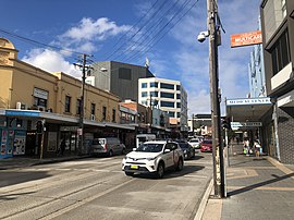
 Liverpool Road, Ashfield | |||||||||||||||
| Population | 23,012 (SAL 2021)[1] | ||||||||||||||
| Established | 1838 | ||||||||||||||
| Postcode(s) | 2131 | ||||||||||||||
| Elevation | 34 m (112 ft) | ||||||||||||||
| Area | 3.5 km2 (1.4 sq mi) | ||||||||||||||
| Location | 8 km (5 mi) west of Sydney CBD | ||||||||||||||
| LGA(s) | Inner West Council | ||||||||||||||
| State electorate(s) | |||||||||||||||
| Federal division(s) | |||||||||||||||
| |||||||||||||||
Ashfield is a suburb in Sydney, in the state of New South Wales, Australia. Ashfield is about 9 kilometres south-west of the business centre of Sydney. The local government of the suburbs around Ashfield is called the Ashfield Council.
The people that live in Ashfield are from many places. 15% of people in Ashfield were born in China.
The number of people living in Ashfield is high in comparison to other suburbs of the same size. Many apartment buildings in Ashfield were built after World War II. Many houses in Ashfield were built around 1900.
The oldest building in Ashfield is a church called St John's. The building was started in 1840.
Ashfield has passenger trains and buses to and from Parramatta and Sydney CBD.[2]
- ↑ Australian Bureau of Statistics (28 June 2022). "Ashfield (NSW) (suburb and locality)". Australian Census 2021 QuickStats. Retrieved 28 June 2022.
- ↑ Transport for NSW, Customer Experience Division. "Ashfield Station". transportnsw.info. Retrieved 2024-12-12.
