Back Britse Eilande Afrikaans Britische Inseln ALS Islas britanicas AN الجزر البريطانية Arabic Islles britániques AST Britaniya adaları Azerbaijani Брытанскія астравы Byelorussian Брытанскія астравы BE-X-OLD Британски острови Bulgarian ব্রিটিশ দ্বীপপুঞ্জ Bengali/Bangla


The British Isles are an archipelago (a group of islands) in north-western Europe. They have a long geographical and geological history.[1] The first people were in Britain by 800,000 years ago (Happisburgh footprints).
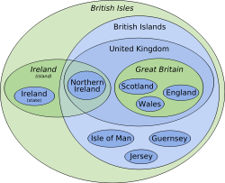
The biggest islands are called Great Britain and Ireland, followed by the Isle of Man, the Isle of Wight and Anglesey. Great Britain, the biggest island, is home to three countries. These are England, Wales and Scotland. The island of Ireland is divided into Northern Ireland and the Republic of Ireland. Great Britain is the biggest island of Europe and Ireland is the third biggest.
England, Wales, Scotland and Northern Ireland join together to make the United Kingdom.
Some people include the Channel Islands of Jersey, Guernsey, Sark in the term "British Isles", but they are a lot closer to France than to Great Britain. In politics, they are British islands but in geology they are French islands.
The writings of the Roman cartographer Ptolemy used the name "Great Britain" for the larger island in the 2nd century AD.
- ↑ Bennison G.M & Wright A.E. 1969. The geological history of the British Isles. Edward Arnold. ISBN 0-7131-2226-9